
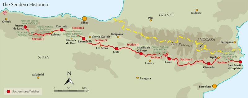
Section 5: from MURILLO de GÁLLEGO to GRAUS
From May 11 till 19 2022
INTRODUCTION
This GR (abbreviation for Sendero de Gran Recorrido in Spanish) runs entirely in Spain, from just under the Picos de Europa, continuing in the shadow of the Pyrenees to the Mediterranean Golf of Roses, from Cantabria to Girona, over 1250 km and 39,000 meters of ascent.
This trail is called “historical” because it runs over paths which have been used since ancient times to connect villages for trade, social contact, and defence. So, you feel like walking back in history passing through deserted villages and long ago revered Ermita’s and Santuario’s.
Spain’s seasoned walkers often consider the GR1 as Spain’s best but least known long-distance hike. We are lucky: John Hayes of CICERONE compiled an excellent guidebook on it.
The route promises as well a real mountainous feel without having to cross snow patches or treacherous passes and with available accommodation in months where mountain huts are still closed.
We decided to go for Section 5 featuring almost every day Monte Perdido on the wallpaper and traversing for us an unknown part of the Aragon region, so, from Murillo to Graus, about 200km over 9 days.
The route is very well documented by John Hayes in mentioned guidebook; so our reports will be brief and focus on some things to watch for or give route recommendations.
THE ROUTE
Please click on above file to have our detailed statistics. Note that “moving time” for us means time walked, including brief stops for pictures, a drink or looking for the trail; not including snack or lunch times!
We left our car in Graus at the Plaza San Miguel and stayed overnight at Palacio Del Obispo (70€) good. (we would opt for Hotel Lleida next time as livelier!). The next day we took out cash at an ATM and took the bus to Huesca (bus stop across the bridge from Hotel Lleida) at 07.45h and the 09.50 h train from Huesca to Canfranc with stop in Riglos, arrival at around 11.00 am. Both interesting journeys!
We stayed in the Refugio de Riglos for 94€ for 2 pp, halfboard. The refuge creates a great vibe for the whole village as a meeting and lunch place for rock climbers and mobile home dwellers up the road.
To be sure we didn’t miss out on anything, and our data were covering the whole section, we walked the interesting 4 km to and from Murillo late in the morning. Around noon, Murillo looked very quiet with only some activity around the shop, La Tienda on the A-132 where “El Camino” basically starts and passes.
This is an important note: from Murillo to Nocito (end of stage 4), the trail follows the new and well waymarked CAMINO DE LA HOYA DE HUESCA for short “El Camino”, from time to time also straying away from the GR1! (so, we stayed with “El Camino” at all times till Nocito)
DAY 1: From MURILLO (500m altitude) to LOARRE (627m altitude): 19.4km, Moving time: 4h14’, 709m ascent and 443m descent.
We measured a lot less ascent for this day than mentioned in the guidebook (this just for once; the other figures mentioned are quite accurate). The highest point today is 1033m around the Ermita de San Miguel and the Torre de Marcuello.
The trail runs down from Murillo to and over the fast-flowing Río Gállego on a newly built impressive footbridge, up and bringing Los Mallos behind Riglos into view. Don’t miss the cute railway station of Riglos! Continue further up to the village where the refugio offers great lunches in a friendly ambience. Look out for climbers on the Red Rocks in front of you when leaving Riglos.
Los Mallos were formed when eroded material washed down from the slopes of the Pyrenees and became cemented together by limestone. Over time, this mixture became compacted into a large mass of conglomerate rock. Eventually, erosion wore away the softer, more porous parts of the conglomerate. The more resistant rock remained, and became the formations known as the Mallos de Riglos, some reaching over 300m height and each one carrying its own name.
The steady and mostly shady climb through the gorge after the village till the Collado de Santo Roman constitutes the main excitement for today! The scenery is amazing; you will share it with vultures gliding overhead and nestling in impressive cliffs above. Don’t forget to often look back at what you are leaving behind in views!
At the Collado (pass), the GR1 splits with El Camino, the latter one offering a perfect resting spot a bit further at la Ermita and what remains of the Torre. From then on, the route is uneventful but not boring.
The church at Loarre offers a good spot for lunch and siesta (trimmed grass and in the shade).
We stayed at the Casa Rural El Callejón de Andresé, an interesting and quirky but excellent B&B with peaceful garden terrace and very good breakfast, 70€, cash payment. We had dinner (tapas) at the Salon Social on the Plaza Mayor with interesting local scene. You must go inside the Salon to see the quirky (again) styrofoam stage sets coming from Ridley Scott’s movie when filming in El Castillo de Loarre.
Note that El Hospedería as all other places looked closed.
DAY 2: from LOARRE to BOLEA (641m): (different route!) 18.2km, 4h03’, 621m up, 752m down, Highest: 1173m, lowest 667m.
The guidebook described an uneventful day when sticking to El Camino, so we decided to take a different route and see what the day would bring.
We decided to visit the impressive looking Castillo, went up the road a short while and soon took a yellow/white marked trail at the horse-riding school. This trail brings you to the gate of the Castle bypassing the ticket office… where -we found out later- coffee and other goodies are served.
From the café we followed the sign to La Ermita Virgen de la Peña, going down a bit onto a dirt road but staying considerably higher than El Camino. There are more signs and yellow/white waymarking to come (so, we ignored Aniès), taking us up and down through forest and scrub on single paths. When in doubt stay high; a path forking off from a dirt road will eventually bring you on top of (and just passed) the Ermita (see pictures), completely restored in its glory. The same path will bring you down to a dirt road and lead you to a sign to “la Ermita de San Cristóbal 2.4km”; ignore again the sign for Aniès, the village already being behind you to your right.
After 2 km on the dirt road, a sign leads you down on a track with faint white marking and a lot of cairns.
This trail is SPECTACULAR and highly recommended (a bit steep and slippery at places but you can hold on onto bush; not dangerous!) La Ermita is no big deal, but the gorge and its surrounding “pancake” rocks certainly are, as impressive as Riglos and the gorge after! (we borrow “pancake” from how the conglomerate rocks in Punakaiki in New Zealand are described).
Note that when coming from Bolea, you would only be able to see the impressive rock formations after passing La Ermita and crossing the river in the gorge!
After the Ermita (look up for it after you have crossed the river; easily missed though…) a smooth 4km path leads you to Bolea easily recognised by its 2 hills the town is built on.
This doesn’t make the day extra hard: we recorded 18.2 km and 621 m ascent for this whole stage.
We stayed at Bolea, Casa Rufino, 50€ with breakfast. As dinner started only late we tried La Muralla which had surprisingly good food served at its outside terrace in the back, facing the old church.
DAY 3: from BOLEA to ARGUIS (978m alt. at El Capricho): 22.38km, 4h40’, 992m up, 701m down, highest point: 1472m, lowest: 641m (Bolea)
The morning takes a steady start up through cherry orchards; the dirt road changes for mostly shady single track at the Ermita de la Trinidad, all the way and steeply up then till de pozo de nieve at 1229m altitude. (Here the GR1 and El Camino split). El Camino follows dirt road in the open facing El Pico Gratal, then turning away from it and finally going straight North with a last tough climb to Collado Sarramiana at 1473m altitude.
A steep path brings you down in beautiful beech forest, reaching a dirt road for the last tedious kilometers to Arguis. Here you should find Ca Il Silva open for some refreshments and/or to book your dinner.
Switch your brain off for the last 2kilometers on the road to El Capricho, passing the once famous Migalon/Barbacana (for sale) and bar La Foz (faith unknown). Hotel El Capricho de Arguis is now run by 2 young sisters and offers breakfast only. (85€ including bf). Use your charm and you may get a lift to Ca La Silva (good!) for dinner…! Everything else in town is closed…!
DAY 4: from ARGUIS (El Capricho) to NOCITO (950m alt): 20.32km, 4h22’, 959m up, 981m down, highest point 1243m (El Méson Nueve)
Note that today we exhausted completely our supplies of water (8 liter for 2 people!. You could take water from the Río Fulmen though when taking a water purifying device…)
We followed the guidebook and the GPS to start the day: you veer off the road and cross a small parking lot in front of Bar La Foz, just under Barbacana. A faint trail, often eroded goes up and starts to follow the wall of the elevated motorway. After having crossed a small stream, the trail joins the waymarked El Camino again, going above the tunnel in which the highway disappears. Shortly after you reach a sign El Méson Nueve , the highest point of today after which the day starts to brighten up fully by entering a rough but pretty valley of the Parque de Guara (which you will leave only at the end of the next day)
Apparently, this valley is in the middle of the Atlantic Ocean and the Mediterranean Sea mixing also typical vegetations from both biotopes.
After Belsué the trail becomes really enchanting by following a stream and offering a few toe dipping spots. Santa Maria de Bélsue needs to be explored a bit or can be a pleasant lunch spot. The deserted village of Lusera is at the rim of yet another beautiful valley, the trail bringing you then up in 3 ascents and descents (2 of them reaching a pass, both at about 1232, altitude, the last one being the unmarked Collado Barbero) on varied but mainly real forest trails.
Only after you have crossed a small, sealed road can you be sure that the climbing for the day is over. What remains is a pleasant 4km descent -as pleasant as descents can be- to your destination, picturesque Nocito!
We stayed at La Casa Villacampa (70€ for the room), having all amenities of a hotel with nice dinner and breakfast as well. It is owned by a French couple. Very good! They can also prepare lunch (some bocadillos) for the next day which you will surely need! Note that Nocito has more accommodation and dining options, but Casa La Mallatta had been for sale for 4 years by then.
DAY 5: From NOCITO to PAŪLES de SARSA (866m) (we got a pick up at Las Bellostas, stats till there): 29.7 km 7h42’, 1099m up, 939m down, highest point today: 1192m, lowest 921m.
A gorgeous day! Would be perfect when 10km shorter!
Note that El Camino is no longer your waymark! The GR1 and the newly waymarked GR268 (Sendero de San Urbez) start your day, up to the Santuario. (The GPX runs slightly different; this will happen often today).
At the Santuario, the GR268 goes sharply north, while the GR1 skirts the Santuario as well as the Refugio de San Urbez, both lovely, and the latter with very warm people! (We tried to book the Refugio as being already 3km into the long Stage 5 but it was fully booked by a group; see our conclusions). Go passed the parking lot and stay East for the following kilometers.
Bentué and Used follow, often with the GPX and the GR1 running parallel. A descent in beautiful forest brings you along the river Used, flowing through waterfall filled pools. One spot (the Salto de Cardito) deserves a stop, a dip or a swim, actually a whole day as a rest day…! Note that we met no people at all here (contrary to the spots the day before around Belsué).
About 2 km after the waterfall, you hit a dirt road leading to Bara, another km further down.
Just after Bara you must cross the river which is about 4 meter wide there! Ideally you carry sandals to help you cross safely. The water is not fast flowing but there are some sharp rocks and slippery algae making the crossing potentially treacherous.
The route then seems to run south (straight ahead for some 150 meters, 90 degrees with the river; the GPX also gives you a faint direction) until you reach a dry-stone wall, the path running clearly behind it towards the east- southeast (look out for cairns as well!).
A tough 300-meter total ascent over a few kilometers follows to Nazare. This abandoned village has a pretty church at its end with picnic perfect grass to sit on! After the church, the GR waymarking becomes very good. Just after Otin when turning left you pass a well with a mechanical pump. A sign marks the water as untreated; we filtered it with our Katadyn Befree and still live to tell…
You continue on dirt road, running parallel with the old overgrown path, passing Lutesa. After a while you will spot a church tower high up in the mountain, the trail seeming to lead you towards it. All of a sudden, the dirt road turns and takes you away into the opposite direction. But your sigh of relief came too early: the route takes a turn and …goes towards that church.
A third climb for the day brings you to 1170m, to Bagüeste and its beautiful Ermita. Cross what must have been the village marketplace and rather new signs will bring you down. For a change but for a last time that day, you will cross a stream at what could be a wonderful (wild ) camping spot , going up on a path leading you out of the valley (the end of the Parque Guara) and bringing you into a new, fertile and agro-cultivated one, right into Bellostas. Apparently, this village has 6 inhabitants left, all men of which the youngest is 67.
Hopefully you have booked with La Casa de Fina (Fina being the name of the cute elderly lady owning and running it) She can send her son to pick you up (it takes only 15 minutes for him to arrive at Las Bellostas after you called her). The 6km from Bellostas are on a quiet road, not unpretty, but simply too much for the day, knowing that there is an alternative …(coming at 20€)
(welcome Spanish for “Can you pick us up now at Las Bellostas”: “Por favor, es possible de recogernos ahora a Las Bellostas?”)
Fina offers you a warm stay with good home cooked dishes and marmalade for breakfast. 30€pp halfboard.
DAY 6: From PAULÈS de SARSA to EL MÉSON DE LIGÜERRE (479m): 22.73km, 4h53’, 554m up, 921m down, highest point: 956m
Note that Ligüerre de Cinca now refers to a village entirely owned and run by the Spanish Workers Union (Unión General de Trabajadores); El Méson is the lower part of the village where the camping site and restaurant La Pedania is, the upper part (4km along the Embalse de El Grado) where the resort (hotel) and its reception are located. (the lower part looked very closed when we passed and walked through the day after..)
We walked to El Méson which is used on the GR1 signs as a destination before Ligüerre itself. (from there, the route turns away from the A-138 and goes north).
An uneventful day, not unpleasant but a big contrast with the day before. The GR1 waymarking from Paulés on is new and good, so, we stayed with it; the GPX will vary quite often today from the waymarking. Till Arcusa you walk amidst fertile, mainly cereal fields. After Arcusa comes a steep climb to 956m altitude. The route brings you then through varied scenery passed Castejón until you face and reach Samitier which probably deserves a closer look (especially the Abadia) but we decided to continue down in the shade to El Méson.
We initially had a booking for a room with the holiday resort of Ligüerre de Cinca (85€). Their restaurant was closed but they could provide a takeaway meal (26€ each) and breakfast (11€ pp), pricey but these red guys know they are holding a monopoly! We then got to know that we had to add 30€ cleaning fee as we stayed only 1 night. And we were advised to rather stay in an apartment for 130€ as there we could heat up our takeaway meal….
The communication went back and forth, mine in my high school Spanish. We told them that an apartment was too expensive and that a few bocadillos would suffice. Maybe they could then also provide a water cooker in the room, which is actually standard equipment in most standard hotelrooms…?! Upon which they cancelled our reservation (the only English they ever used), adding (In Spanish) that “130€ for an apartment being too expensive is your opinion” …
We wonder what the workers by which grace and contributions they exist and live from would think of these prices. And what they would think of this comment? We thanked them for their hospitality!
And so, we arrived at Escanilla, at A Chaminera, run by the flamboyant Anna! (55€ for the room, 18€for a varied menu, 7€ for breakfast). Very good! And you can choose times of dinner and breakfast.
Escanilla is 20 minutes walking or… use your charm and Anna’s husband may come and pick you up (not even a 5 minutes’ drive)
DAY 7: from ESCANILLA to TIERRANTONA (627m): 25.37 km, 5h30’, 906m ascent, 766m descent. Highest point: 806m, lowest 447m.
The only drawback by staying in Escanilla is that you (may) have to walk back down the road (about 2km) to El Méson first to reconnect with the trail. (you could get a lift from the husband again when not leaving too early. Or just lift.)
The route along the Embalse and to Ligüerre (about 4 km in total) is okay. After having reached Ligüerre – actually a lovely location with a nice amalgam of old buildings, pity we couldn’t stay there! – you go down, cross the bridge on the road and then go up on a path to your left; that’s when the spectacular part of the day starts as the trail leads into a gorge or “l’Entremon” and has at places been carved out of the cliff face. You can follow the blue of the Río Cinca down your left side.
When leaving the path at a dam, look at the church tower poking out of the reservoir, go through 2 tunnels and then continue along the reservoir. The trail then takes you further up high but on a pleasant path for about 2 km. A short descent, cross a stream and a short up to El Humo de Muro. The village will look sleepy by then, but the owner of Las Bodegas de Claveria may be repairing his car and very willing to open the restaurant for you!
Hopefully refreshed, the afternoon has some pleasant undulations, until you reach a sign for Tierrantona 3.8 km. Time then to switch off your brain and finish off the walking for the day. The valley you are walking in now- Las Fuevas – is very green (late spring), cultivated but dotted with animal husbandry barns.
Casa Puyuelo is a bit further than the school and the centre of social life in town: the elderly playing cards, the middle-aged sipping wine and the young chain smoking and drinking beer. Next doors is a well-stocked grocery shop with lovely storekeeper. Open from 10.00 till 14.00 and from 16.00 till 20.00.
Casa Puyuelo, 60€ for a room. A la carte dinner, served at 20.30h. Very good!
DAY 8: From TIERRANTONA to SALINAS DE TRILLO (794m): 15.92km, 3h24’, 593m up and 420m down, highest point: Mirador de la Fueva (1033m)
A smooth and fun day! And well waymarked now! Everything goes well, even after Formigales (the GR1 does not take you through the village anymore) when the trail goes up but nicely and steadily on the sort of path, we like the most: shady, on dry earthen soil with the occasional pebble or rock, with dried pine needles on the ground and pine scent in the air. (Or was it oak leaves and the scent of dried acorns?). And magnificent scenery on one side.
Stop at El Mirador (just a sign), have a bite and marvel over the La Fueva Valley and Monte Perdido in the distance. You can still see El Humo and where you entered the valley the day before.
Continue happily to the hilltop village of Troncedo, worth exploring! And from there you again see the Castillo de Samitier and where you came from 2 days before.
Half an hour later you arrive at Salinas where you find the cosy Casa Bielsa looking over the village (probably 20 inhabitants). The lovely owners will spoil you during your whole stay with their home grown and made goodies, sampled on their idyllic terrace: a variety of cookies and self-roasted almonds with your coffee; olives, cured ham, sausage and goat cheese with your aperitif; a wonderful dinner followed by home made liquors (pousse-café)… And again, pampered with breakfast, with an almost forgotten to exist scrambled bacon and eggs! (Jose also puts a liter of wine on the breakfast table because “you will need it during the day!”). This all for a price which (should) will make you feel uncomfortable…..
DAY 9: From SALINAS de TRILLO to GRAUS (473m altitude): 25.88 km, 5h28’, 894m ascent and 1197m descent. Highest point: 1124m (Castillo de Panillo)
A long final day with 2 very different halves: a pleasant (small) half on mainly forest paths until Pano and a possibly hot (and bigger) half because in the open, after.
The trail is not that well marked today, especially after Pano. (Before Pano: often a bit overgrown).
What Salinas was missing in charm and location, Trillo is making up for. But it looked as if the village was already uninhabited…
Some rolling trails after Trillo until a steady climb brings you then to a ridge where you stumble upon works in progress: Pano and its restaurant l’Alcina where the tables were being set for… a television crew, making a documentary on the project done by the Swiss entrepreneur and his three sons to preserve the village beautifully by making it into a hotel and its usual amenities. We featured in the program playing guests while sipping a welcome cold tea.
After Pano, a sealed road now brings you to a junction on a hilltop, where the GR1 takes you onto a dirt road, and this basically for the rest of the day. Views are still great, after a while even containing a Buddhist Monastery to your left.
The GR1 and the GPX will differ often. Anyway, after seeing a sign “Graus 9.9km” and where 2 dirt roads are in front of you, one going up and leading to a green window barrack, take the one at the right staying at the same height. Faint GR waymarking on a left tree should guide you. Also, in Grustàn we missed the signs and followed some unclear paths downhill.
Note 1: follow Graus, Plaza Mayor; second note: the village you see in the valley shortly after Grustàn is NOT Graus; Graus is much more to the South and not visible until you have reached the busy road (A-139) into it. You don’t have to keep walking onto that road, there are GR1 signs taking you along the river (Rio Ésera).
Upon arriving you won’t be able to resist Hotel Lleida and its terrace (don’t bet on anything else open at that time of the day, neither!)
Well done!

CONCLUSIONS
- We agree with the author of the guidebook: this long-distance walk will keep on impressing us and this much longer than the Andalusia trek and the trek in Basque country we did before! The varied scenery with Los Mallos, trails leading into conglomerate rocky gorges, hilltop villages, romantic streams flowing in pools or gushing as a waterfall together with friendly locals and the authenticity of how life still can be, makes us wanting to go back already! This region was for us also an unknown: it is basically deserted but leaving as such sheer and rugged beauty!
- Traversing this section was NOT a walk in the park; I would even say that this walk is tougher than what we mostly do in the high mountains! This because you often climb the same elevation but in much warmer conditions than in Alpine conditions! When in high mountains, you start the day always at cool temperatures, ascending when still cool and having the sun at its highest after you have reached the mountain pass of the day after which you start descending already…
- In this respect, be sure you carry enough water! There are few water resupply possibilities! Also, take a water purifying device with you, just in case! The same for food! Just assume that you will not be able to buy anything! We always carry a good mix of nuts and dried fruits and cheese and dried sausage. Most places you stay though will at least be able to give you some slices of bread!
- Carry enough cash! There were no cajero’s anywhere we passed! Loarre, Paules and Salinas can not accept digital payment. (see a list of our stays hereunder)
- If we were to do it again, we would stay 2 nights in Nocito: the first night in the village (Casa Villacampa). The second day we would walk (go up to) and stay with the very friendly people of El Refugio de San Ūrbez. We would then walk (without luggage evidently) to the waterfall and while the day away (or lift to Bara and walk back on the trail for about 2km to the waterfall)
- The GPX is not really necessary but helpful (and often saves time in finding the right trail!)
- Note that the whole of Section 5, and specifically the Guara offers also a lot of magnificent camping spots!!!! Evidently, you have to carry all supplies with you, then …. (We haven’t seen any ranger whatsoever on the trail at all..)
- Basic Spanish is handy, is actually a must! At least, master the vocabulary of making a reservation, dates and numbers, pick up, food and drinks, payment….
- We have not met one fellow hiker at all during these 9 days! Also, Maria and Jose were telling us that no Spanish ever are staying with them…
