
November 15 till 30, 2019
INTRODUCTION
1. The Manaslu Circuit (MC) is along the Annapurna Circuit (AC), the 3 Passes Trek and the Upper Mustang Trek one of the iconic and growingly popular circular treks in Nepal.
2. The Manaslu circuit is advertised as a 14-day “tea-house trek” which circumnavigates the 8th highest peak in the world (8,156 m) thereby crossing at its highest point the Larkya La pass (5160m) .
3. The trek has all the elements of other treks in Nepal including both Hindu and Buddhist culture, protected wildlife, rhododendrons and wildflowers, raging rivers, precarious bridges and stunning mountain scenery.
4. The trek basically follows the Bhudi Gandaki (the Gandaki river) all the way to its origin just before the Larkya pass. In terms of difficulty, it is comparable with the AC Trek or EBC trek. Its highlight is without any doubt the spectacular views of the Manaslu and neighbouring snow-covered peaks.
5. Via the internet we entered “a 14-day” package tour at a guaranteed departure date with Nepal Eco-Adventure for 1300 USD each, including permits, transportation to and from, guide and porter, accommodation and 3 meals per day. (For the MC the agency can also lend you for free a -20C sleeping bag, a duffel bag and walking sticks). Out of the abundance of agencies advertising on the internet (on “tourradar” you find already 110 of them) we chose to contact a few; speed, and accuracy of response made us to opt for Nepal Eco-Adventure; see http://www.nepalecoadventure.com
6. As we were half November already it turned out we were the only ones on the tour. (Note that we originally wanted to do the MC plus Tsum Valley, but time constraints made us opt for the 14 day MC only). Starting half November turned out to be a very good choice: the weather was splendid and the trails were quiet!
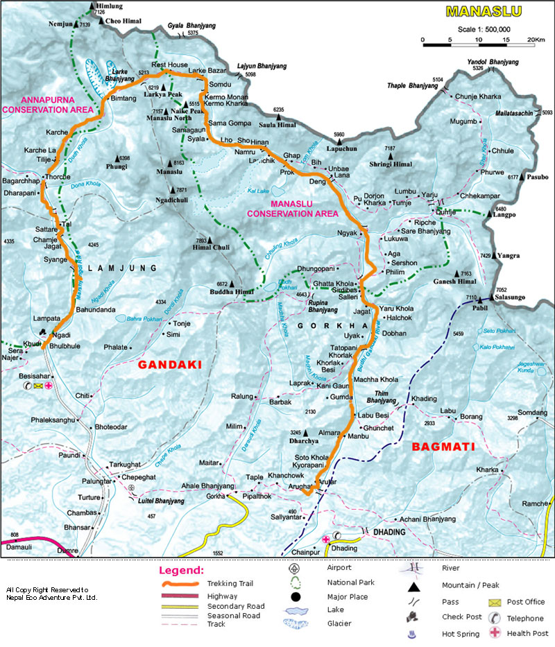
ROUTE

Click on underneath link for the MANASLU CIRCUIT STAGE STATISTICS. Note that we indicate “time walked”, stopping our GPS only for longer tea or lunch breaks. No stops for mule caravans or photo ops.
The day before our departure we went to the Eco Adventure office to hand in our passports and passport pictures for the permits.
DAY 1: drive to SOTIKHOLA: 3h30’; walk to LAPUBESI: 5.8 km (estimate), 1h18’
On November 15 at 08.00 am, our guide Dorje and porter Lila picked us up in Thamel.
The Phrithvi “Highway” which connects KMD with Pokhara was uneventful that day although it is infamous for holding surprises (read: “delays in the form of traffic jams”) particularly on the stretch coming out of the KMD valley.
After having crossed the Trisuli river and soon after Arughat Bazar the speed dropped to nothing more than walking pace as the “road” simply doesn’t allow for more. You start following the Budhi Gandaki or Gandaki Khola or Gandaki river and this for the next 9 days.
After a lunch stop, the road became even worse but the scenery all the better. A Mahindra minibus with a group of about 16 trekkers managed to keep up with our jeep! We were happy for the Mahindra quality, less so for the people on the bus. (Note that the next weeks we got more and more respect for the Tata brand!)
We cannot imagine these kinds of roads being accessible during monsoon season though…
After we arrived in Sotikhola, Dorje suggested to walk for about 1-2 hours to Lapubesi to stretch the legs. The sun had disappeared behind the mountains leaving the guest houses in Sotikhola in the shade for the rest of the day making the concrete structures seem rather unwelcoming. We hiked for about 1.5 h on the main dirt road (little traffic) to an inviting Laxmi GH because it came with a pleasant flowery courtyard and is run by 2 smiley women. (Laxmi: garden, hot shower and western toilet. Good food)
DAY 2: from Lapubesi to DOBHAN: 19.12 km, 4h13min, 538m elevation gain, 364m down.
The trail from Sotikhola to Machhakhola has apparently changed a lot since the Earthquake of 2015. You basically now must walk on the dirt road to Macchakhola, not unpleasant but not the real thing either. Here you cross the river and you leave road construction and thus “the main road” behind you. (rumours have it that this road will be built by the Nepalese all the way to Namrung where Chinese roadbuilders will meet up, thus offering another connection between Chinese Tibet (the politically correct name!) and Nepal. So, we would say better hurry up to do the MC, but telling from the materials and equipment being used especially on the Nepali side, you are probably still okay for the next 10 years…!
We had lunch in Tatopani (“hot water”): the hot springs have been turned into a hot waterspout cum laundry platform for the whole community. The attraction of Tatopani is now mule caravans trekking through the narrow main street. Interesting village and agriculture life set in a backdrop of mountains and waterfalls becomes the main scenery afterwards.
In Dobhan we stayed in the Royal Mountain GH; we opted for another GH than Dorje suggested as the latter one was near noisy construction and had only concrete to offer while the former had a rather nice garden as a courtyard. GH okay.
DAY 3: from Dobhan to PHILIM: 19.82 km, 5h05min, 956m up and 372m down
Today you will cross 5 suspension bridges. “Suspension” is just the correct name for this kind of bridge as it contains always an element of “suspense”…
From Dobhan on you really are in the Nepal mountain countryside as you imagined it! You follow the Gandaki in various forms, life becomes harder and Dal Bhat simpler.
Just after Jagat after having crossed the suspension bridge and just after the small power plant, a trail has been blasted in the mountain flank and becomes REALLY suspenseful (see pictures!) and dodgy if having to pass mule caravans. Note that you always have to choose mountain side when mules pass and pay extra attention when they go up carrying cargo. Gas bottles are the most dangerous load as they are sticking out quite a bit! And mules are unforgiving!!
We had lunch in Jagat, Mountain Shanti Hotel. Jagat and Salleri are rather posh as the army has some barracks there.
We stayed in Philim at the New Royal Garden Hotel in the middle of the village, ideal to enjoy more village scenes. (But the GH is not really recommendable! There are more GH just before the village on the east side (to your right) and looking better… or continue another 1.85km to Chisopani, see under)
DAY 4: from Philim to BIHI PHEDI: 21.19 km, 5h18’, 1017 m elevation gain, 602m down.
A stunning day of walking through the Gandaki “canyon” from Chisopani to Dyan (Deng) and crossing 7 bridges of which the last one is a wooden one!! You first go through Chisopani (also named Ekle Bahti) with plenty of good-looking guest houses! Soon after you pass the trail towards Lokpa and Tsum Valley. Lunch in Nyaphedi Nubri Village GH where they serve a tasty Dal Bhat!
This is a long day but probably the most scenic of all, and this with hardly any snow-covered peaks in view yet…!
We stayed in the only GH in the middle of Behi Phedi (3 buildings) . Okay until its neighbours decided to start a quarrel late in the evening and this to be enjoyed by all rooms – just across the trail. Best to avoid Behi Phedi at all and continue to Bur (or “Bihi”) about 10 minutes further or Gyap (about 20-30 minutes)
DAY 5: from Bihi Phedi to NAMRUNG: 14.54km, 4h11minutes, 999m up and 382 down.
From Ghap (Gyap, Gap) on – with plenty of GH- , the trail goes gradually up through impressive woods. The tree line in Nepal amazingly runs to about 3500m while in Central Europe you hardly see any trees anymore above 2200m; in New Zealand the treeline even stops at 1100m! The semi-tropical climate must account for that.
Look out for Langur monkeys and Mountain goats, particularly before crossing the bridge in Suksung (to the right of the bridge). They seem to live in groups together, probably living in symbiosis for safety….
In the morning, the Gandaki is still a wide river but runs as a gushing mountain stream through the forest.
At the entrance of Namrung, the Four Seasons Resort with German Bakery is welcoming you. They offer rooms from 500 to 3500 NPR. (we sampled their cakes and Illy Coffee in their pleasant courtyard. Very welcome!)
We stayed at the very end of the village on the left in the New Tibetan GH. When in doubt: it is the one where the old man in the courtyard is continuously chanting Tibetan mantras…
DAY 6: from Namrung to SHYALA: 14.23km, 4h23’, 1131m up and 225m down
The trail to Lho takes you through quite a few villages showing the hard life these people are having to scratch out a living in the high mountains. Some were still harvesting or threshing millet and bucket wheat, some were putting straw in stacks.
You are definitely making a trip back in time – although you probably have never seen in your life this kind of agricultural scenes at all! When we passed quite a few families were also making their way down with their cattle seeking refuge for winter in lower lying valleys.
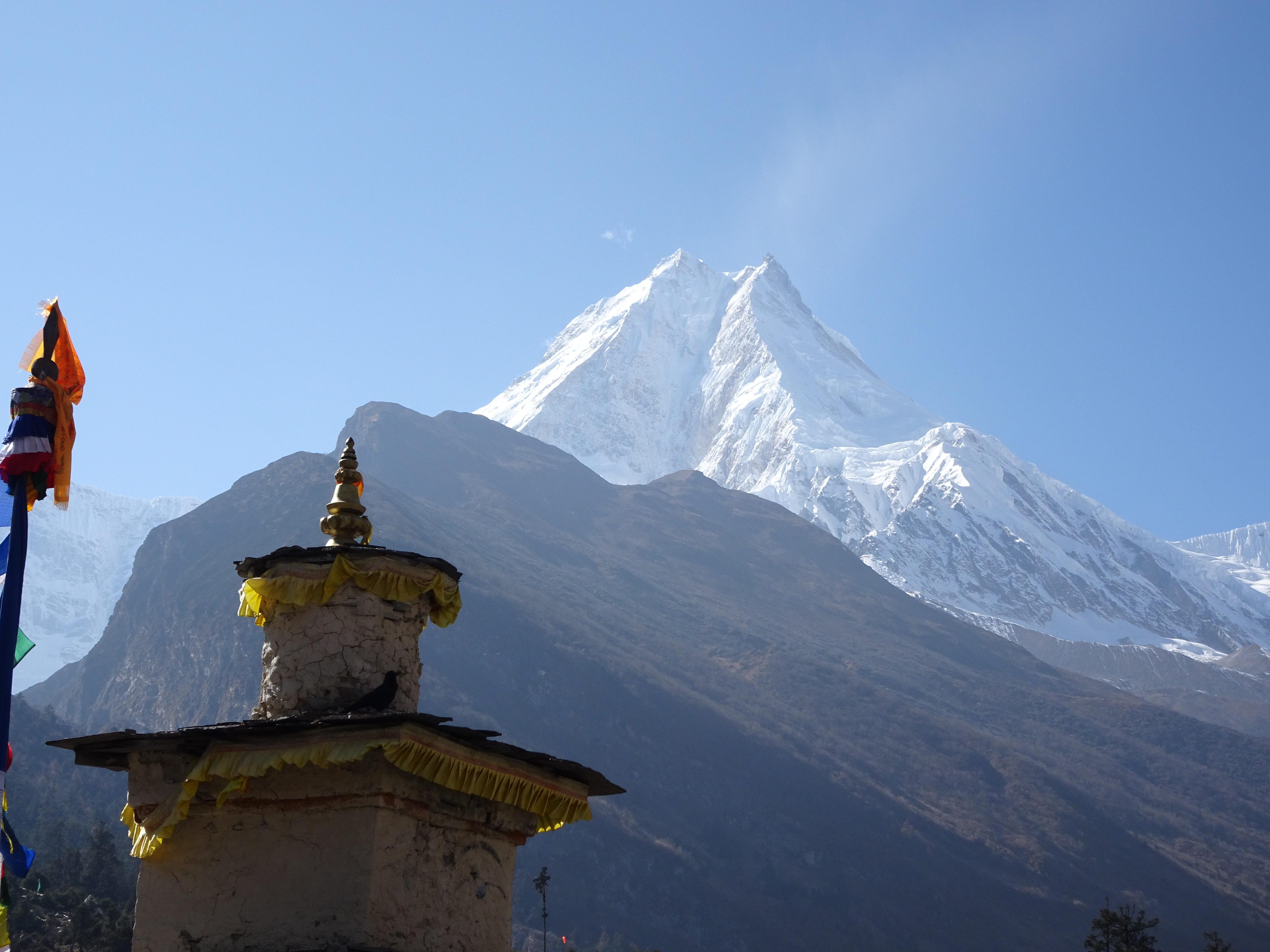
From Lho to Shyala you ascend through mainly pine forest this time. And finally, just before Shyala you get your first glimpse of the Manaslu!
We stayed at the entrance of Shyala in the Buddha GH. Good. From now on at 3500 m altitude, the air becomes thinner, breathing gets quite a bit more difficult and you will need a blanket on top of your sleeping bag for the night!
DAY 7: from Shyala to SAMAGAUN: 4.26 km, 1h08minutes, 140m up and 122m down.
The next 2 days (actually 3 days were foreseen in the itinerary) are for acclimatising! We surely needed it!
A short but pleasant walk brings you to Sama. We stayed in the middle of the village across the Tourist Information Centre in the Manaslu Guest House which has 2 larger rooms with toilet and shower in annexe – you don’t need to hold back on your tea intake this evening! The GH has a large rooftop terrace enjoying great views and warmth from the sun.
We had a pancake upon arrival, left our backpack in the room and then went for a beautiful and easy walk to Birendra Lake. (3.59km return, 1h13’ return and 150m up). We didn’t go to the Pung Gyen Monastery as all monks had left for the winter -they don’t come as hardened anymore like in our days…!
It is worthwhile to go to the lake while enjoying the beautiful weather, sitting in awe between the hundreds of cairns, watching the impressive Manaslu’s (Himal and South) and hearing their glaciers alive and full of activity.
The little hike also fits well into the physical advice to walk higher and sleep lower as a means to cope with altitude sickness.
DAY 8: from Samagaun to SAMDO: 7.76km, 1h58min, 353m up and 43m down.
We rejoined the Gandaki river on a nice trail surrounded for 360 degrees by snow covered mountains. Morning frost is common now..!
Samdo is a village where unfortunately just in front of it a few guesthouses have been dumped. We stayed in the Tibetan Twins Hotel, an interesting concrete un-structure and poorly managed. The neighbouring ones didn’t look better but were better managed apparently. On a next visit we would probably opt for the Shambala, but no guarantee for much better…
Anyway, the stay in Samdo gives you again the opportunity to climb a few 100 meters higher in the afternoon and to get better armed against the thin air. Going through the village and up behind it is not unpleasant. When lucky you will have a few vultures circling above you when resting around the mini stupa and gompa on the mountain flank above the village. Towards the east you are seeing Larkya Bazar (just a name, nothing to see) and the trail leading further through the mountains to Dharamsala .
DAY 9: from Samdo to DHARAMSALA: 6.08km, 2h20’, 603 m up and 43m down.
The climb goes gradually and bistari-wise to Dharamsala. Likewise here, go for a walk in the afternoon and look for blue sheep-what’s in a name?! (see pictures)
But if Sampo is a rabble or hotchpotch of dumped concrete structures, Dharamsala is a dreadful – purposely so you don’t stay longer than needed? – but necessary stop before the 5000m crossing. You can actually consider it as being a base camp before the ascent of the Larkya Pass. (We needed the stop! It took me 3-4 hours in the night before my breathing became normal; Kobi had a bit of a headache until she got up. Otherwise we had no serious symptoms of altitude sickness)
In Dharamsala you sleep 4 next to each other in an otherwise clean room; blankets are payable, toilets are repulsive, the neighbouring inhabitants in tents are partying all night and at 01.30 dogs are chipping in the fun as well barking… Fortunately the guides shorten the pain (?) and want you to wake up early as the weather on the pass can turn less favourable usually around noon. All guests are offered a staggered start so the GH kitchen can cope with the breakfasts.
DAY 10: from Dharamsala to BHIMTANG: 16.16km, 7h21’, 700m up and 1415m down
At 4.30 am we set out with headlamps on and warmly dressed in multiple layers – and ideally with some hot water in a thermos flask; everything else freezes! You start at minus 4 and will end at 22C in the afternoon (In November that is)! Take also some extra energy bars! And warm gloves!
Take the climb at a steady pace allowing for not getting out of breath. We were lucky: blue skies, freezing but no wind, all the way to Phedi!
The pass comes as most passes come: not as a beauty spot but as a milestone to be taken and crossed. Rather an anti-climax… We measured 5056 m at the highest point, officially it says 5160m, anyway the highest we’d ever been!
When going down you immediately feel better! And you can start enjoying the fabulous mountain ranges ahead and next to you!!
At about 4500 m Phedi looks inviting and offers a welcome stop and hot noodle soup! Good to know that its Guesthouses (3) also have some rooms!
We continued torturing the quads to stop in Bhimtang, staying in the first GH on the right: the Manaslu GH while the one on the left looked much more inviting (but too busy according to Dorje..).
DAY 11: From Bhimtang to TILCHE: 19.11km, 5h08’, 259m up and 1631m down.
Again a stunning day with an abundance of varied scenery: the Himlung and Cheo ranges behind you, the Dyth Khola (Milk river) next to you (and often domesticated goats following you as well!), enchanting forests to walk through, wooden bridges to walk over and the Manaslu greeting you again! Enjoy the hike, enjoy the lunch at the idyllic 7 sister GH (Kharche or Surki Khola) .
From Gowa on you follow again a dirt road- with little or no traffic.
This to arrive in Tilche where a GH with hot shower and annex toilet awaits you. We stayed at the North Face GH, good. The nearby power plant had some issues though, so we had a candlelight dinner.
DAY 12: From Tilche to DHARAPANI: 4.86km and 1h06’; 67m up and 381m down. and drive to BESHI SHAHAR: about 4.0 hours.
The walk to Dharapani was a formality, on dirt road but no traffic still. In Dharapani you pass a sign directing you to the AC trek. (Dharapani would make an interesting and more convenient place to stay a bit longer in between 2 treks).
Then followed an interesting jeep ride to Beshi Shahar: bumpy and dusty but scenic. You encounter the odd AC trekker taking the dirt road towards Dharapani instead of walking on the original trail on the other side of the Marsyangdi river or instead of taking a jeep up to Pisang or Manang to start trekking from there (what we would do if doing the AC).
Note that fellow trekkers reported a 3 hour wait on this road the day after. A truck broke down and blocked it.
The road has also traffic signs in Chinese which should normally alarm any driver.. But apparently it is only to warn Chinese construction workers.
Beshi Shahar is the first larger town you enter in 2 weeks, offering all amenities larger towns are usually known for. Not unpleasant if only the pavements would be wider and walkable. But it is really an unnecessary stop unless you continue the day after to KMD (about 2 hours to Dumre and 4-6 to KMD) . We stayed in the Puspanjali GH, restaurant ok but rooms drab; with hot shower and toilet in annexe, though. Good food, cold beer and a charming lady owner smoothening opinion.
Day 13: to DUMRE and to BANDIPUR (own arrangements)
The tour guarantees also transportation back to KMD. We decided to get off in Dumre and take a taxi to Bandipur (700 NPR).
CONCLUSIONS and RECOMMENDATIONS
1. Trekking the Manaslu circuit is just magnificent! It comes as a total experience: the scenery, the ambience, the mountain people, the fellow trekkers….
But it should also come as a sobering experience: how lucky we are to be able to do this trek and to take it as a holiday while you traverse the livelihood of people that are trying to carve a living in that very beautiful but harsh and unforgiving environment!
2. The trek as such is not that hard: nothing more than a series of serious hikes in the Alps, Pyrenees or any mountainous area. But evidently, the altitude can get to you! Therefore, it is really advisable to follow the itineraries suggested by the guides! The extra day in Samagaun (or anywhere above 3500 m) we did not take but during the shorter walk days we went for an extra hike up in the afternoon which we felt as being very helpful!
We had altitude sickness pills (acetazolamide , the generic of Diamox) with us but didn’t feel seriously enough the consequences of altitude to take them. The last hundred meters before the Larkya Pass were quite tough though. Note that the locals advise to eat Garlic soup… tasting definitely better than Diamox!
3. So, trekking 12-13 days should be plenty unless you want to keep on walking down towards Beshi Sahar from Dharapani (it didn’t look that attractive to us because of – Chinese – road works.!). So, we would advise to drive and start in Machhakhola (the trek becomes really interesting once you have crossed the river!) and end in Dharapani where you cross the Marsyangdi river (from there take a car down to Beshi Shahar) Of course, from Dharapani, you can take a jeep up to Pisang and start the Annapurna Circuit! You are already acclimatised for it, then! And why not continue further and in Muktinath start the Mustang trek! The ULTIMATE TREK! (all GH treks)
4. For our next treks in Nepal, I think we will not opt for a package anymore: i.e we will pay the agency separately to apply for permits (see http://www.nepalimmigration.gov.np/page/about-trekking-permit for applicable laws), for a guide – a guide is compulsory for restricted areas; actually, we would advise to always hire a guide! – and porter if needed (but remember: it means employment! ).
During the trek, we will pay ourselves for accommodation and food (not all agencies may be open for this though!) As such you have more say in choosing places you see that look attractive. With a package where the guides choose the accommodation it looks as if next-doors is always better than the guest house where you are staying…
But we didn’t get to really understand the social dynamics in the Nepalese mountains… Evidently the guides go for a GH where they are well treated, their accommodation is good, and the food is good. And where they are welcome to sit and gather in the warm kitchen. We don’t think about that! We see a nice GH and immediately want to stay in that one…But it’s not because a GH looks welcoming to us that the guides and porter will sleep decently. Looks can deceive……
What is not helpful neither is that prices for food and accommodation in GH are apparently fixed by law! So, a main element of competition, of being good and out-standing has been eliminated. This is probably also the reason why most of the staff or owners of the GH are quite indifferent to you. Not unfriendly but just not really interested. But they are towards the guides (language of course also play a role..!)
5. Take enough cash with you for the walk! When on a package, you still want a regular stop en route for a hot tea or coffee and you still want a pancake and coffee after your siesta. When paying all yourself, count on 3 times 500 NPR for breakfast, lunch and dinner, 3 times drinks at 200 each, a pancake and coffee at 400, a couple of drinks en route at 150 each, accommodation at 800 RFPS for a double room …
So, count on at least 1000 NPR per person per day extra when on a package, 3000 NPR per person when paying all yourself. And this without the extra Mars bar (150 to 300 depending on altitude) and beer (500 to 800).
Note that when withdrawing money from the bank, you are generally charged 500 RPS service charge per withdrawal and this comes with a MAXIMUM withdrawal amount – when you choose “fast cash” generally only 10,000 NPR! The most favourable bank at time of writing was NILBAS Bank where you could withdraw 35,000 NPR for 500 NPR charge per withdrawal. So, better bring US$ but also here the exchange rate shows about 3-4% difference with the official rate (116.5 NPR to the US$ at time of writing)
As a note, GH/villages worth exploring/staying: Lapubesi (Laxmi GH), Jagat and Silleri (both larger villages with plenty of GH) , plenty of good looking GH in Chisopani (Ekle Bahti) about 10 minutes after Philim, Bur (10′ after Bihi Phedi has one but interesting looking GH), Gyap (Lama GH at the beginning of the village, before the bridge), Namrung (Four Seasons GH), Shyala (Buddha GH), Sama (Lama GH) , Sando (probably the least bad is Shambala GH).
6. We were rather well equipped for this walk. One thing we will certainly bring next time though is a thermos flask for hot water, particularly for the day of the crossing where your water supply in Camelbak or plastic bottles freezes. click on underneath link for a trekking packing list.

7. Note that we also brought purification tablets which we didn’t use. We used instead our Be-free from Katedyn to filter our drinking water. All villages we passed seem to be connected now with a reliable running water supply. To be on the safe side we mostly filtered the water, but for brushing teeth we often didn’t bother, with no problems.
8. On our agenda for the coming years: Mustang trek (starting from Muktinath) and continuing all the way down to Gorepani and probably finishing off with the Khopra trek.
