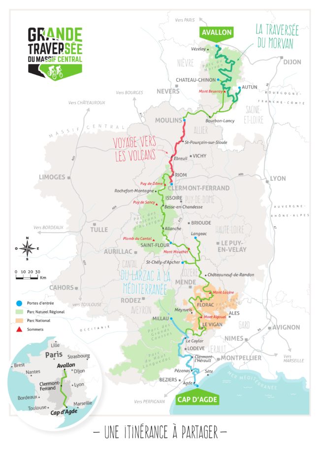
From Clermont-Ferrand to Le Vigan
From August 30 to 10 September 2021
PRELIMINARY
- See introduction (also for the MAIN CONCLUSIONS already on the whole route) on page “The GTMC-part 1”
- From Clermont-Ferrand to Besse-en-Chandesse we already did in 2020.
- For the Cévennes we planned shorter stages because according to the Topoguide, they involved a lot of climbing and the descriptions were too vague to get a realistic idea of what would be on the menu.
- We parked our car in Besse; we had agreed with somebody there to come and pick us up with our car in Le Vigan.
ROUTE
Click on Download for our stats
DAY 12: From Clermont-Ferrand to Volvic: 21km, 614 m D+, 2h00, V4 and from Volvic via Le Vauriat to Laschamps: 39km, 829m, 3h25, V4 + V3
What we didn’t realize when planning the route was that after leaving CF to pick up the trail again you cycle back on the road you came the day before, so once again up the Col de Bancillon but in the opposite direction – which is easier now but still not exciting- and again through bustling Blanzat and arriving at the point in Malauzat where you could have gone straight to Volvic the day before. Normally you don’t explore the guidebooks so thoroughly beforehand; nor is it mentioned in the guidebooks nor do you expect this.
And since there is no accommodation whatsoever in Le Vauriat, we did 3 stages that day.
Also, good to know is that you leave at 350 meters altitude (CF) and end at 950 meters (Laschamps) with the highest point at 1100 meters (Col de Suchet).
After Malauzat you enter the woods; after Argnat it becomes steep and bumpy. Therefore, the V4.
You will not enter Volvic: just before you climb a steep left arriving in open planes. From then on, the Puy de Dôme will stand out throughout the rest of the day!
Half an hour later, on a short stretch in woods, you come upon le Manoir de Veygoux, a museum dedicated to the French Revolution… They also have a small restaurant, where you can dine dressed up as Robespierre or Josephine. (As with everything in France, check what days they are open if you’re counting on it for lunch!).
The afternoon started with a difficult climb – therefore, V4. We didn’t notice Le Vauriat. From Beauregard on the ride is just stunning and becoming great fun from Col de Suchet on when gliding on forest trails with arrival just before Laschamps in the uniquely located Archipel Volcans!
After a shower and the laundry, enjoy the garden with a view of the Puy de Dôme and with “une blanche volcanique”. Hotel Archipel Volcans: 78€ pp demi-pension. Is also a good place to have a rest day with maybe some walking around the Puy de Dôme…?
DAY 13: From Laschamps to Orcival: 21km, 421m D+, 1h56, V4
It was raining quite heavily, so we decided to start a bit later; and stop in Orcival.
The route came with a steady and beautiful start in forests up to Recoleine, followed by “false flats” in open nature with hints of great views through curtains of rain…. Just behind the church of Saint-Bonnet-prés-Orcival is a steep climb – or a steady walk up.…
We had booked at l’Auberge Le Cantou, but actually it is now Hotel Roche and the Restaurant is Le Cantou, each with separate accounting… but the evening part of the demi-pension still happens in le Cantou (65€ pp)!
Hotel Roche very kindly allowed us – wet to the bone – to check in even though it was only 1.30pm! (This is something to keep in mind in France: especially smaller hotels have an hour at which you can check in, usually quite late in the afternoon! Before that hour there is no one at the reception or they use an excuse (time needed to disinfect…?) to not let you in.
Orcival is one of those villages that is just perfect in size to have a pre-dinner stroll around with visits of the Romanesque church and the chocolate production shop with interesting museum!
However, restaurant Le Cantou is run by (most certainly!) an ex-Legionnaire who manages to ruin the ambience even before you order anything. Before you go there, google what “Pounti”, “Aligot” and “Omble” mean because they are on the menu; “Truffade” you should already know from previous restaurants in the region. Most other French guests, when from other régions, do not know those dishes either! (Remember: “La France, c’est l’Auvergne et quelque chose autour”!)
Now with this knowledge, you could play it in such a way that you pretend not to have understood his French explanation – not so difficult because it is coming at full speed. Let him lose his patience, maybe try: “what’s the difference then between Truffade and Aligot?” – until he sends the junior waiter or waitress to take over. (or think for a moment how John Cleese would handle the situation…). With their explanation, of course, you understand immediately.
But we did enjoy the food!
DAY 14: From Orcival via Murol to Besse-en-Chandesse: 40km, 1020m climbing, 3h45, V3 + V4
Just after breakfast, with cold legs and still quite some Pinot Noir from the Côtes d’Auvergne (price/quality far better than the overpriced Burgundy wines!) loitering around the body, the road goes scorching hard up, but paved…. ! Expect more than 25% denivelation!
But then it becomes a wonderfully lovely ride with scenery reminiscent of Austria or Switzerland but with volcanoes (“Puys”) as background.
Again, we follow the signage rather than the GPS, all the way to the gorgeous lake before Murol. You first arrive in Chambon-sur-Lac where there is a bakery. Further on the other side of the lake are two restaurants/snack bars where the croque-monsieur and waffles come out of the freezer and the fresh pancakes are only served after 15.00 h because only then the chef-pancakes arrives.
After Murol, there is still some hard work to do because on rocky soil and often worn out by quadbikes and other noisy nuisances.
We stayed in Le Pont du Roy in Besse-en-Chandesse (officially Besse-et-Saint-Anastaise), a friendly Dutch B&B. (90€ room with breakfast).
Besse is worth a visit, and okay for a day’s rest! You can recover in restaurants Le Bessoi and La Souillarde after (short cycling) trips to beautiful Lac Pavin and surroundings. We read somewhere that Nicovélo in Besse besides doing VTT rentals could also repair bicycles on appointment (Check it out beforehand!). Our brakes had been grinding down our discs already for quite a few days by then, but we had come to the end of our holidays anyway…. (the following we did in 2021)
DAY 15: From Besse via Jassy to Allanche: 57 km, 1171m climbing, 4h19′, V3 + V3
You are in the middle of Le Pays des Volcans and the altitude makes itself felt: we had to rig the bikes at 6 degrees Celsius. (Besse is just below 1000m high)
It will be a nice but serious morning – you can quickly take off a layer – on a nice variety of routes but all coming with beautiful panoramas in which the “Puys” stand out and with various birds of prey on the lookout above.
After Jassy (except for a farm that sells cheese nothing else noticed what looks like accommodation or nourishment) the route takes us towards Col de Chamaroux. You will soon notice that there are 2 versions of it: one for cars and one for cattle and mountain bikers; this last one on coarse gravel and 200 meters higher…
The trail also warns for dangerous Canadians…
After the Col we are treated with a hilarious descent of about 6km in rolling no man’s land (it reminded us of Montana and Wyoming) to les Pradiers where bar-restaurant Le Pasadou had closed its doors already at 14.00h, just when mountain bikers are having their first coffee and cake of the afternoon!?!
Note that just before Allanche, in Veyrines there is a sign “Cascades de Veyrines”, according to the locals worth a detour for a picnic and for the waterfalls (Nor the Topoguide nor the website mention it!) .
In Allanche we had booked a room in the father and son run LdF Le Relais des Remparts. Bien sympa! 75€ for room, 7€ for breakfast. The wall “decorations” give a good indication of what is at the top of the menu in the evening.
DAY 16: From Allanche via Nessargues to Saint-Flour: 47km, 875m up, V3 + V5, 4h31m
The morning offers a nice warm up in rolling forests and on a former railway, all the way to Chalinargues. With a nice church but not much else worth mentioning.
The description of the route on the website then warns of a technical descent; we classified it as a rather beautiful singletrack through forest with an occasional dismount.
Nessargues has everything on offer but is not very pleasant. To help better digest lunch, a steep but do-able climb leads you to La Combe Robert with more rolling work till after Coltines where you bump into the quite impressive castle of Sailhant!
Then begins an impossible stretch of “sentier granitique” which is not even described as technical on the website…!? And before Andelot you get another “warm down”… up!
Note that the route takes you to the top of the old centre (le bourg) of Saint-Flour. We booked in Hotel l’Ander which is now moved to and called l’Ancien Grand Seminaire. 114€ with breakfast and a nice view! We went for pizza beside Le Hotel du Nord. Good!
Saint-Flour is inviting enough for an evening stroll after dinner.
DAY 17: From Saint-Flour via Ruynes-en-Margeride to Paulhac-en-Margeride: 41km, 1288m climb, 4h23. V3 + V5
The day starts rolling and interesting along the l’Ander and after that through beautiful forests. Gentle, all the way to Ruynes.
Note: if you want to see the railway bridge “Viaduc de Garabit” designed by Gustave Eiffel (worth the view!): after about 13 km you come to a little stream (Ruisseau de Mongon that flows into La Truyère; when you come to a railway you are already too far). There you have to go left according to the GTMC signs, but go to the right instead for about 500 m (we estimate). (You can also see the bridge from above from the “aire de Garabit” on the A75 motorway).
In Ruynes, a bakery and Tabac Presse with coffee on offer provide the necessary energy and moment of reflection before reality kicks in: another 860m climbing for the day, actually hard labour all the way to Paulhac.
The first 4 km are murderous: “très difficile” according to the website actually means : “impossible”, so expect a tough walk up with bike. The ridge on top offers a bit of solace and beautiful views (we think) of the Cévennes and Mont Lozère! Also the descent to La Musée de la Résistance brings some distraction. (But don’t expect the restaurant there to be open!). But is then again followed by another fierce climb on tough surface; you even get the feeling that you keep circling around the “table d’orientation” of Mont Mouchet … It rained heavily during our passage; the panorama remained hidden from us.
However, you are in an area where picking mushrooms and blueberries bring variety to the daily menus (“myrtilles et champignons” sound even more appetizing),so you may even come across a living soul.
A bit of a technical descent brings you to Azenc where an asphalt road leads you to Paulhac. You arrive in the middle of a church, a barn, a manure pit and truly, an auberge!
Au Bon Accueil. Very simple but neat! And with a tasty 4 course menu; a feuilleté with 3 types of self-picked mushrooms as a starter. We can still pass it on so the picker – the friendly owner – does know something about mushrooms! 40€ pp half board or “étappe soirée” as it is often cutely put in le métier.
The evening walk after dinner in Paulhac can be short…
DAY 18: From Paulhac-en-M via Le Sauvage to Baraque-des-Bouviers : 36km, 844m climbing,V5 + V3, 3h12′.
The morning brings you another impossible climb – so it becomes rather a walk with bike – of about 6 km followed by a welcome piece of sealed road in rolling country and through tiny Chanaleilles. This looked soulless, also the Auberge du Pont.. And then, for a change again hard work almost all the way to Le Sauvage.
The name reflects appropriately the ambience there! (But why the GPS stops here?). However, for the second time during our entire trip through Le Massif Central, there is a GTMC marker; this probably to justify the EU subsidies for the route?! They should have parked a food truck instead… (But apparently the buildings in the distance house the gîte “la Domaine du Sauvage”, well known to Compostela-pilgrims). The entire domain of Le Sauvage is said to be owned by the Chirac family. Yes, that one!
Your cursing of the Topguide and all its route planners in the morning soon disappears in the afternoon! They take you for a blissful 13km through forest and heatherland – and a harbinger for the coming days! – to the lovely located Baraque des Bouviers (ignore the road running next to it! )
French bureaucracy had given us a good runaround to book a place in the Baraque! They hid behind the excuse that the entire organization of the Baraque and the Auberge were being moved under a different administration. So, we were calling back and forth to eventually get a whole dortoir (normally for 8 people) in the main building of the “acceuil” of the park (Le Baraque) . For 16€pp. (The Auberge (hotel with restaurant) was closed, but is said to reopen in 2022). So, look up both if you want to stay in this location (should be worth it when the Auberge reopens!!).
When staying in the Baraque, you can order food and have it delivered (minimum order of 40 €) from Restaurant Laures in Grandrieu. (Note that Grandrieu can also be an alternative starting point for a five-day tour of the Cévennes – it may be more accessible than le Baraque?! See recommended 5-day itineraries in conclusions).
DAY 19: from Baraque des Bouviers via Le Giraldès (at 15km) and via Laubert (at 39km) to Bagnols-les-Bains V4 + V4 (V5), 61km, 856m climbing, 4h31minutes
In a lyrical mood (and even before the aperitif that evening!) we declared today the most beautiful ever on a mountain bike!
You leave the beautiful spot of the Baraque for a steady climb. You follow the ridge through heathland with great panoramas to your left. The trail is a bit technical but of the pleasant type. Then you get an exhilarating descent all the way to Giraldès (stop now and then to take in the landscape!). This in turn looks like a nice village (or an alternative to Baraque) to spend the night.
After Giraldès comes a tough climb but on sealed road; the route continues undulating after, followed by an uninspiring climb (because on worn out asphalt) to the top of le Cheval Mort. The trail takes you then up towards le Truc de Fortunio but fortunately just before the top forks to the left and offers a fun roll down all the way to the dam of Le Lac de Charpal.
You follow this artificial lake until you reach an old railway (the beginning was completely flooded) with further descents to Laubert. This is another trifle where cycling through offers its greatest excitement…
Some ups and downs further to justify the 20km but in attractive settings, past Le Fort de Tournel (was in scaffolding) and all the way down to the D901. In St Julien-le-Tournel, the route planner thought that another 2km walk with bike on GR trail had to be added on, just impossible surface to cycle on (Therefore a V5 in parentheses for the second stage today). And so you enter Bagnols-les-Bains through the backdoor…
Bagnols is quite a cozy town along the Lot which is still nothing more than a stream here. The town also has a nice campsite, a Vival with lovely shopkeeper and some hostels all belonging to the same owner. We stayed in Les Chemins de Francis. Very good ! 65€ pp demi-pension (“étappe soirée”).
DAY 20: From Bagnols-les-Bains via Mont Lozère to Pont-de-Montvert: 46km, 826m climbing, 3h34, V4 + V3.
Note that you don’t go all the way to the top of Mont Lozère; you cycle around it, fortunately! You do get to the Col de Finiels, though. Also, from today on you are in the Parc des Cévennes: the signage (arrows) for the GTMC – and other indications – become very small. This probably as not to startle or confuse rabbits and deer?
We actually became even more lyrical today by the beauty of the scenery and by the sheer pleasure of mountain biking!
The website warns of a 10km climb immediately after the start that morning but it comes steadily and on mixed but good surface and along the idyllic Auriac. A ride on singletrack in heatherland follows (a bit more technical than the day before, though). This until you start a very enjoyable descent around the top of Mont Lozère, coarse gravel preventing you from going too fast ..!
Then another climb on asphalt road (3 kilometers at 3-4%) to Col de Finiels – where in Belgium you would be met commercially and logically with a coffee house and pancakes. However, here is now another GTMC marker to celebrate your exuberance with for so much beauty…
But you will even be more thrilled with the breathtaking descent afterwards, frolicking between beautiful “hameaus” in Tuscany-like landscapes and this all the way to Pont-de-Montvert! Here for once you can celebrate your excitement with a Méga-Coupe Glacée de la Lozère in Café-Restaurant La Commerce!!!
Also for sleeping there is an interesting address: Hotel des Cévennes, completely renovated and coming with a passionate owner creating “une nouvelle vague” in the business! 65€ pp demi-pension in chambre “cosy”. Very good!
Pont de Montvert will invite you for a short evening stroll after dinner…!
DAY 21: From Pont-de-Montvert to Florac: 30km, 644m climbing, 3h7minutes. V5.
The low average of this stage is an indication again of the surface on which we are going to advance on today. We do start with a crispy climb to the lovely hameau of Hermet with impressive views till after the crossing of the D20.
The website recommends here to continue the road to Grizac if technical singletrack is deterring you. Do NOT follow their advice! By doing so you would miss the romantic bridge of Ramponsel (Rapunsel?) dating from very early times but restored in simplicity by some of her friends. You will indeed have to push your bike before and after the bridge, but a bit more or less pushing the bike today will not make any difference! Plus, this bit comes in fairytale forest (“vraiment bucolique”)!
Grizac sits high, overlooking a vast green valley. After the village the trail stays bumpy- i.e. your bike keeps on jumping next to you – descending along a ridge in pine woods, almost all the way to Saliège. After which it goes up again, on foot.
Actually, until after km18 you are more next to the bike than on it. “But so beautiful here…!! 😊”
In Bédouès you hit the road – lunch or coffee possible at bar-restaurant Cévenn’Sonne… (Cévennes – Chemin de Stevenson- Les Cévennes sonnent – … You get it… 😉 ?) Then, easy to Florac.
We stayed at Auberge les Gorges du Tarn. A classical Logis de France (LdF) coming with a highly recommended restaurant. But much ado about nothing, we thought. And with lots of noise coming from a waitress who thinks etiquette requires shouting the menu at the top of her voice.80€ étappe soirée pp. Good.
It never ceases to amaze us that the standard term of staff in restaurants in France when clearing the dishes is: “tout c’est bien passé”? Literally: whether everything went well… This is a question you get more and more all over France and mostly from young staff. Perhaps a typical question for an internet generation? Whether the food has ended up safely in the stomach? No unexpected errors when downloading? Was the connection good? Was Capslock off when spooning the food in?
You rather expect “was everything to your liking” or “did you enjoy the food” as a question to which you can then answer “c’était bon” or “délicieux” depending on the degree of satisfaction. “Whether everything went well” you rather expect to hear while waiting outside the delivery room of a maternity ward.
When in Florac, certainly go for a drink and enjoy the “couleur locale” under the platane trees of the Esplanade Marceau Farelle (the central market actually) and on the terrace of café du Globe. (Florac is not that appealing, we thought.. )
DAY 22: From Florac to Saint-Enimie: 31km, 533 m up, 2h53minutes, V5
This stage you will cycle mainly next to the Tarn, meandering through its Gorges. Beautiful but technical!
A steady climb to warm up today with a nice passage and crossing of the Tarn in Ispargnac (with coffee opportunity on the market!). Further to Quézac where you cross the river again and now cycle on the north bank of the river. Well, cycling …? Rocks, gravel and tree roots seem to make the Tarn even more impressive. Take a rest in Castelbouc!
After about 29 km you pass a “Parc des Loisirs” and come to a bridge to your right. Here the website (not the Topoguide) warns you for a narrow trail steeply hanging over the river… We heeded the warning – also because we had enough that day of all the walking and pushing the bike – and took the glide for the last 2 kilometers on the D907bis to Saint-Enimie.
This is a pretty town on the Tarn; but can be rather busy! We could still book Auberge Chante Perdrix, about 700 meters outside town, up the road to La Malène on the D907bis. 84.5€ for room with breakfast. Good!
We had dinner on the terrace of Hotel du Moulin (booking required!) Crayfish feature on the menu; expensive and not impressive. The Bordelaise sauce is nice, though. But worth a visit for the nice French Bistro ambience.
Saint-Enimie is attractive enough to enjoy a relaxing afternoon watching the river and world passing by… Or you could also rent a canoe and do a trip on the Tarn (but this couldn’t excite us because not that much water in the river …)
DAY 23: From Saint-Enimie to Nivoliers: 634 m of climbing, 19 km, 1h52m, V3
Instead of following the GTMC route to start with, we cycled up the D986 to Col de Coperlac!
This because now both the website and the Topoguide are warning for the trail being very narrow and close and – at places – high above and overhanging the river. (We plan to hike this bit in future – it is also GR marked; what comes as GR marked on the GTMC is usually not cyclable….)
The climb to Col de Coperlac comes steadily with the Gorges du Tarn as wallpaper! 450 meters altitude difference over 7 km and on a smooth asphalt road with not much traffic.
Once at the top you are on the Causse de Méjean, coming with its own biotope and sparsely populated with hardened cattle breeders and immigrants who love”le grand calme”. Or on 400 square km2 600 inhabitants who do not consider themselves “Cévenols”.
Tiny Nivoliers lies in a fold on the Causse just before the reserve for Przewalski horses. Auberge du Chanet was fully booked but we could have dinner there. It turned out to be the best dinner and with not your everyday dishes on the entire GTMC route!!
We stayed in nextdoor B&B l’Ange Gardien for 81.5€. Very Good!
DAY 24: From Nivoliers to l’Esperou via l’Hom and le Mont l’Aigoual: 38km, 1153 m climbing, 4h38′. V5.
You pass (walk) through the Przewalski reserve – the horses you (probably won’t) see were declared extinct in the wild in 1960 but 13 animals turned out to be scattered in a few zoos around the world. After a carefully planned breeding program, the horses were saved for posterity and a group was even released into their original habitat in Mongolia.
After that you get a beautiful last bit of gliding over the Causse ending at an asphalt road where the GPX also stops. To your left there is a sign for l’Hom with gîte possibility and in the background le Chaos de Nîmes-le-Vieux (a rugged rock formation – you have come across some jagged rocks already on your way down).
You pass the Col de Perjuret, descending! A fun col, for once! (Luckily there will always be some motorbikers smoking on the top, otherwise you would not even have noticed it!). You leave the road soon after to start the walk to Col de Fourques. Rolling down for a while after, passed grey and dreary Cabrillac and next to the D18 on a cattle walk. When crossing the stone bridge and on the right, high and in the distance you notice the communication masts on Mont Aigoual, “beckoning”.
When you have crossed the D18 again where the tree with swing is, then its time to put on your walking shoes back on for a 45-minute hike up. Even the GTMC signs are missing from then on; they relied on the GR signs instead….
You finally arrive at a GR sign with “Mont Aigoual 6.5 km” on and leading onto a dirt road. You can start biking again then, actually the reason why we all came here .. Very doable from then on and even pleasant after all the hiking, on an average of 5 to 7% climbing to the top (the last 1.3 km from the Menhir de Trépaloup we just went for the asphalt option. )
The Auberge de Mont Aigoual welcomes you there with café, restaurant, and dormitory (all too new though to be really cozy – expect a large self-service restaurant popular on French ski slopes). But, stop whining now for once there is a café!!
The descent is often on rolled paths that are being prepared for winter, for skiing or langlauf (country skiing) until you pass the water dividing line at the Office de Tourisme du Mont Aigoual where everything that runs east of it flows into the Mediterranean and the rest to the Atlantic Ocean. Notice the lovely valley just next to the Office: La Vallée-du-Bonheur (valley of Happiness with the ruins of Notre Dame du Bonheur hidden in it). Continue down through forests to l’Espérou, a small ski station.
Hotel du Parc was fully booked with hiking groups, so we stayed at run down Hotel Touring. But it does have a new and separate restaurant in the village: resto Le Dahu, also rather a ski buffet ambience but bien sympa. 65€pp demi-pension.
DAY 25: From l’Espérou via Salagosse to Le Vigan: 617m climbing, 36km of which 7 to 8 km on foot. 3h59. V5
Note that from Molières on we took the road to Le Vigan (so for the last 5km).
You start the day like a day of mountain biking should start: with a relaxing 11 kilometers through forest and on former rail track, all the way to Col du Minier. Some coarser gravel will prevent you from going too fast, though.
Shortly after the Col it is time for your morning walk with bike, going down this time and in wonderful oak forest. After Salagosse – out of this world – we couldn’t resist following the road while keeping an eye on the trail on our GPS screens, a beautiful descent on asphalt all the way to Mars (the village, this is…)
Then another kilometer of footwork to Bréau. This village comes with bakery and a platane tree marketplace. A steep climb follows on sealed road at around 25% inclination, with undulating trail afterwards, on the bike now and all the way to proudly sitting Esparon. Then a long way of misery (5km) to and even through Molières where we had enough of it and cycled all the way along the main road to Le Vigan. (Also, because we were picked up there at 14.00, so we had to be on time).
Le Vigan is a rather large town with interesting-looking nooks … We will find out when we will start there for the rest of the GTMC.
CONCLUSIONS
We have already put our most important conclusions re the route at the beginning of GTMC- part 1. Here we just want to repeat that in variety and beauty the GTMC is simply MAGNIFICENT and the mountain bike experience UNIQUE: a succession of pleasantly long stretches of exhilarating or technical descents that require quite some skill after combinations of gradual or steeper climbs, in open nature or enchanting forests! And to make the holiday completely unforgettable: great food and wine in charming settings!
The Topoguides give an interesting introduction to what can be seen along the way; the signage is good but in the Morvan we rather trust the GPS, from Bourbon-Lancy on (so, after the Morvan) we prefer the signage because very recent..
However, we have some COMMENTS and would like to make some RECOMMENDATIONS! This either because some things are not mentioned in the Topoguides or because we do not always agree with what is being stated. It is also quite obvious that the guides are written for the young and technically very proficient mountain biker who rather makes day trips and this without luggage.
Our comments try to give a more realistic picture and are practical, aiming to make the GTMC more popular for any kind of cyclist, especially for those who want to do longer stretches of the Traverse as a holiday, by nature the slightly older cyclist who has the time to do so.
Who knows, one day there will hopefully be a GTF: Une Grande Traversée de la France, from the border of Belgium, Luxembourg, or Germany, through La Lorraine and les Vosges, and then following the current GTMC all the way to the Mediterranean!?
In any case, we will certainly do the remaining route from Le Vigan to Agde in the coming years!! And redo some stretches again now that we know better what to expect and how to tackle them. (See also further: five-day recommended itineraries)
COMMENTS and RECOMMENDATIONS:
1.Use TUBELESS tires in the Morvan! Otherwise, your GTMC may become the GECC or La Grande Exercice de Changer (et réparer) Chambre à aires, a great exercise in replacing and repairing inner tubes. This is because of the thorns of brambles that pierce like needles through the outer tires (and don’t forget to bring tweezers to remove them from the outer tire if you are not tubeless!)! And since most “bocages” consist of bramble hedgerows, cycling with inner tubes is like playing Russian roulette! Even Michelin tires do not help!
In the Morvan we had 9 flats between the two of us. From Besse on only 1.
2. When we pushed our bike up again or hobbled down on rocks and tree stumps on a so-called V3 – the ratings of the Topoguide – we often wondered what V4-V5-V6 could be like, then? In the Topoguide, no stage got a higher gradation than V3!!?? Or what is the point of grading routes if for more than half of the grades – certainly from our V5 rating – you need to be a circus artist and work for Cirque du Soleil to stay on your bike? Where even Tom Pidcock or Mathieu Van der Poel – himself with an impressive pedigree – must push their bike. …!
A task for the routeplanners: from the Cévennes on try to look for some more bike-able routes!
3. Also the daily denivelations, the D+ are often seriously underestimated (see our statistics: we had 4 Garmins and 1 Wahoo the first week, 2 Garmins and 1 Wahoo after)! This is not really a big problem because the experience is in the beauty of cycling. But a good (mental) preparation, knowing what the day is going to bring contributes to that experience; a lack of preparation or mental preparedness does not let you experience beauty to the fullest…!
4. We would strongly advise against gravel bikes at all! Front suspension is okay, no back suspension needed.
5. We also wondered how you could manage with a tent tied on your handlebars so you can hardly see where your front wheel is racing to …? In this respect, autumn is also not advisable when a layer of leaves is covering the trail. Somewhere in the Topguide it is also suggested that you can pull your luggage on a trolley/cart behind your bike…?! The author clearly had a smoke too much when he wrote this. Our advice: stay in hotels or campsites with cabins!
6. With an electric bike? Well, I wouldn’t want to push that 15+ kg bike – with saddle bag and frame bag on top – along the Cure, the Cousin, all the way past La Pierre Qui Vire or halfway up the Mont Aigoual! And you must be extra careful if you decide to go electric because you haven’t cycled for a while! After all, higher speeds require higher skills!
7. In the topoguide and in various literature advertising the GTMC, it is also stated that the route can be done “en famille“……??!! If your wife is looking for one more reason to file for divorce, she will surely have that one after you have advised and taken her and the children on one of the stages and you have both been carrying the children’s bikes more than the children have cycled on them!
8. If there is one stage you could try with the family, then probably the one from Moulins to Chatel-de-Neuvre which we have rated as a V2 and taken as standard to grade the other stages we have done (see our statistics). This stage has a nice combination of single track along the Allier, some rolling stretches in open nature and ends with some wonderful forest trails: 34 km with 322 meters of climbing and with possibility of lunch in Besson as a welcome break. This could be a first test to see what the family can handle!
9. You must include in your planning that after 2 weeks on the trail, you will need a day off to have your bike serviced! Anyway, be sure to start with a tiptop bike and bring spare brake pads and derailleur pad SPECIFICALLY for your bike! Bicycle workshops are only in larger cities, and you often must leave the route for them! (And in France everything always seems to be closed just when you needed something. Was Murphy French?)
10. HOW TO RETURN to the place of your departure where you went to by car?
- Go by train, not by car….
- The return itinerary probably scares you when it shows that it’s fastest to train to Paris first before heading south again…?
- Navette Retour or “return shuttle”? Is expensive and the recommended “cap-liberté” mentioned in the book refers you to a taxi company anyway. We were quoted 540 € to be driven back from Besse to Avallon! (is 350 km one way).
- La Malle Postale seems to be a service that can take you and your luggage to and from. But we have no experience with it.
- It should be possible to organize this in a different way?! Where you leave your car, surely there must be someone interested to make some extra money and come and get you with your car…!? (That’s what we did for our part 2)
11. Some other practical tips:
- In addition to sunglasses, neutral goggles (even if you do not wear glasses) are advised to cycle with through the woods in darker weather; this protects your eyes from low-hanging branches and brambles.
- Check with the hotels when you can check in in the afternoon
- Check if they have a safe bike storage when booking (if not “partenaires of the GTMC”)
Find a list here of ACCOMODATION possibilities we have used:
12. Some proposals for FIVE-DAY itineraries
- In the Morvan: see the route we propose; is by far the most beautiful and most fun of the region
- In Le Pays des Volcans: you could start in Charroux instead of Chantelle if you want a more beautiful starting place or if you are looking for a 4-day itinerary
- In les Cévennes: As long as the Auberge in Baraque des Bouviers is not open, Grandrieu could be an alternative starting place; or Giraldès; Note that we were rather negative about our last stage: l’Espérou to Le Vigan, but Salagosse and Esparon looked interesting; you could also let your itinerary stop on Mont Aigoual (the Auberge) or in l’Espérou
ENJOY!!!!
