
From hut to hut on the “Chariots of Fire” trail
From June 21 till June 30, 2022
INTRODUCTION
- Carros de Foc is an impressive multiple-day circular hike in the national park of Aigüestortes I Estany de Sant Maurici in the Catalan Pyrenees, province of Lleida, near the city of Vielha in the district of Val d’Aran. We discovered this walk in CICERONE, shorter treks in the Pyrenees by Brian Johnson. (We earlier walked a loop in French and Spanish Basque Country described in this guidebook as well, see page).
Where the name for the walk comes from has become a bit of a mystery: originally there would have been a challenge among the hut wardens to finish the loop and thereby ticking of all huts in one day. This probably shortly after the film “Chariots of Fire” was nominated best movie in the Oscars of 1981….?
- The loop as such connects 9 mountain huts (refugi) over about 70 km and a total elevation of around 5000 m (own stats) with the highest point being Coll de Contraix at 2745m. (This is without the extension loop to Refugi del Pra de la Font which is not that popular). Note that the mountain huts often have impossible long names; we are using the one name under which all are commonly denominated
- The trail runs across peaks and valleys traversing river meadows, quarries, pine forests, plenty of mountain lakes and tarns and sights of snowy peaks. You will pass some of the roughest and most spectacular granite terrain in the Pyrenees with plenty of boulder fields to cross…

- The walk is usually done over 5 to 7 days as the distance between some of the huts is relatively short; if you have less time or don’t want to complete the loop, there are various paths connecting refugi over different mountain tops.
- The loop has 3 rather easy entry points, see Route under. (So, when you walk to and from an entry point, the total distance and elevation evidently goes up).
- The marking: the official website of the route states: “The itinerary has no special marking. In some parts, the itinerary shares parts with the GR 11, where we will find red and white marks. Other parts are marked with wooden posts painted in yellow, and most of the time we will follow the route thanks to the milestones (a heap of stones, cairns) that other mountaineers left before for us. Using a map is an essential requirement.” A detailed map of La Travessa Del Parc Nacional, Carros de Foc, can be ordered at www.editorialalpina.com or can be bought in Vielha at bookstore Plumier in the Avenida deth Pas d’Arró 30, close to the “office” of Carros de Foc. We also downloaded the GPX route which was helpful.
- You can only stay at the mountain huts with an e-mailed confirmed reservation and a deposit of 15 € pp and per night (half board being 62 € pp); book your place online way in advance on www.carrosdefoc.com (especially weekends get booked early!) Note though that on this website you will only be able to book after also having paid a forfeit per person of 30€! This for a card which you can get at entry point and stamped at each refugi (as if you were on a pilgrimage…) and a t-shirt and a map of the trails (which you should normally have bought before you start the trip….!) To avoid this 30€ forfeit, book your places on www.refuseonline.com. You can also go to the office of Carros de Foc in Vielha… contrary to what is listed on their website, it is only open in the morning. To change bookings you can call them, but not too early in the morning…
THE ROUTE
Possible entry points:
- Refugi Restanca from Arties
When having your own transportation, this is the fastest and easiest! Drive from Arties – look for Sant Pelegri and follow the Camin de Pruedo that runs South for about 4 km around Mont Montardo, up to the parking lot of Pont de Ressec. Park your car and hike up to the hut (1h15), first along the dirt road and then up a forest trail from Pont de Rius. You can also get taxis all the way to this point.
- Refugi de Colomers from Banh de Tredos
When having your own transportation, drive up the pretty valley of Banh de Tredos, park at the Hotel Balneario de Banh de Tredos (you are not allowed to drive higher) and hike (yellow signs through the forest) to the Arribada Taxi Colomers for about 5.8km and 377m elevation, and then further to the refugi de Colomers, about 1h and another 300m elevation. There are plenty of taxis servicing the line to the “Arribada Taxi Colomers” as well!
- From Espot : a few possibilities:
- To Refugi Mallafré: drive through Espot (quite a cosy mountain village with quite some accommodation possibilities!) up to the national park car park (Aparcament de Prat Pierró/Sant Maurici). From there you can follow the GR11 to the refugi de Sant Maurici Ernest Mallafré (about 1 h), commonly known as “Mallafré”. But Mallafré is the least attractive Refugi of them all, so, continue for about 1.5h to arrive in the friendliest (what’s in a name?) and brand new Refugi of Amitges (at 2366m alt). (This is the option we would go for if we were to do the loop again; explanation in conclusions). (Note that there are also 4×4 taxis that can bring you all the way to Amitges. But you will have to re-adjust your intestines and push up your lungs back in place after arrival there.)
- To Refugi JM Blanc: either drive to Prat Pierró and follow the signs to JM Blanc, 2:30h and 9.2km up on a dirt road but in beautiful surrroundings; or leave your car in the village and walk up the steep GR11.20 (signs starting in the Carrer de Peguera) which connects with the dirt road about an hour before the refugi.
Underneath we summarize the route we did with just a few observations – for details the Cicerone guidebook is good enough.
Note that when we booked some refugi were already full, so we were not able to stay at JM Blanc and Amitges, the most popular huts.
For a list of our stats, press underneath file. Also, in conclusions we describe how we would do the trail if we were to do it again. We did now 8 days, but we would do it comfortably in 7 and in a different order.
We drove to Pont de Ressec from Arties (look for a sign “Restanca” from the marketplace across the bridge going south) and then walked to Restanca (1:15h, 598m up)), arriving early afternoon where we stayed. An impressive location. Preparatory works on the turbines running from the dam and under the hut were being done.
You are only allowed in the sleeping quarters around 15.00h. The staff (especially the warden) is not very friendly; he did not warn us neither about the conditions of the trail to Ventosa.
DAY 1: From Refugi RESTANCA (2010m) to Refugi VENTOSA (2215m) via Coll de Tumeneia (2604m): 6.5 km, 4:03h, 651m ascent
We opted to go via the Coll de Tumeneia which is now the actual trail of de Carros de Foc (CdF)… But upon arrival in Ventosa, the warden told us that we should NOT have taken this trail – and we should have been told at Restanca! – as there was still quite some snow enroute… Fortunately, we always carry crampons in the high mountains (and we have decided from now on we will also carry walking poles with which you cross snow easier). We found it strange that we were the only ones on the trail that day although we saw quite some walkers setting out in the morning.
Luckily it didn’t rain! Although at the end of June (and a prolonged heat wave in the valleys till just before), it was freezing cold when climbing the steep boulders on all fours towards the top. The marking is existing (yellow dots or cairns) but often takes a while to spot…. And of course, when snow patches, the signs often run through it…. We had to cross 3 significantly long stretches, but doable with crampons. (Note that the scale of the trail’s profile in the guidebook is too large to show a realistic feel of today’s walk as well; this is actually the case for all stages!)
The descent is – contrary to the ascent – quite smooth and running through lovely meadows and lakes (estanhs) and ditto cows… In all a beautiful trail and much shorter than what the author states…
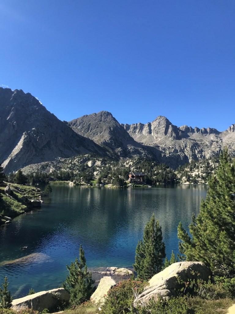
Ventosa is in a spectacular setting and one of the best mountain huts on CdF, allowing early access into the rooms, having good food, great wines and very friendly staff (all cheery ladies!).
DAY 2: From VENTOSA to LLONG (1987m): via Coll de Contraix (2749m): 10.7km, 6:34h, 698m ascent
This is the toughest day on the CdF because you will have to climb – again very often using hands as well – long stretches of rough boulder field and finally scramble up scree towards the very top! After the top, the hard work is not finished: your hands will continue to be tormented! Plenty of people on this trail, though!
The days starts easily, smooth, and even idyllic (don’t know where the author of the guidebook gets his “rough descent” from….?) and in sharp contrast with what follows after. Then comes a first stage using all fours towards the Estany Gran de Colieto (you will have looked up towards it already and mistaken it for the top…!) This mountain lake (rather a meadow) brings you to 2500m and in full view of the “pass” where you will go over. More boulderfield, more cairn spotting and most probably some snowy patches on the menu…! Hopefully the weather is good so you can enjoy the challenge… The last hundred meters will make you scramble almost vertically up in a two step up, one step sliding down rhythm to the Coll.
Misery is not finished after the top, it continues down all the way until after Estany de Contraix.. The small weather station looks as if things are improving… but just slightly. It will stay rough until you have reached a grassy floor, when things end up looking pastoral again…
After the bridge, you turn left and up a dirt road to the Refugi. Llong is a rather basic mountain hut (one shower, changing room is basically the sitting area…) but wonderful to sit outside when sunny; and friendly people. You are allowed to go to the sleeping area for a nap or change clothes.
DAY 3: from LLONG to COLOMINA (2420m): Via Colladeta de Dellui (2577m); 12km, 4h24, 855m ascent.
Today comes as a relief after the hard work yesterday; also a chance for the skin on your fingers to start growing back…. In all, a beautiful hike in splendid and interesting surroundings! And often almost on manicured paths in comparison with the “trail” to Llong.
Still some boulderfield to do, though, just to make the transition not too drastic!
This day could also be called the day of 1000 meadows… Towards the end you follow some old railway tracks used for the construction of the dams around, finally following GR signs all the way to the Refugi which is again in a spectacular setting overviewing the Spanish hinterland.
The Refugi is brand-new and well managed (all friendly guys this time, pumping heavy metal music in the kitchen) and with awesome views.
DAY 4: from COLOMINA to MALLAFRÉ (1893m), Via Collada de Saburo (2688m) and Coll de Monestero (2716m) (leaving out the small loop around JM Blanc): 12.6km, 5h27, 572m up.
The day starts interestingly looping around 2 dams, but also with 2 lung openers (steep ascents) bringing you first to 2542m and then another one up to 2668 (Saburo). We chose to skip JM Blanc (wouldn’t do that again as it turned out to be our favourite hut when we visited later, both in location and staff (but always busy because of this!)) and veer left at the Estany de la Llastra bringing us to Coll de Monestero.
This Coll holds a big surprise as you will descend from it with each step sinking in deep sand – the last thing you would expect here! After having emptied your shoes, the trail becomes pleasant all the way to Mallafré. This is the poorest of facilities on the CdF, definitely when bad weather forces you to sit inside. But it is run by friendly guys, not that practically astute though and loving (and insisting on) their cigarette breaks.
DAY 5: from MALLAFRÉ to SABOREDO (2299m): Via Amitges (2365m) and Port de Ratera (2594m): 11km, 3h43, 804m ascent.
The start of the trail today on the GR11 lets you enjoy some touristy laid out tracks and facilities around the Estany de Sant Maurici, then passing the Cascades de Ratera, connecting again with the dirt road which 4×4 taxis follow to Refugi Amitges. Even when not staying here, do enjoy a coffee inside to sample what you are missing by not staying.
After the refugi, you stay to the right of the Estany del Barbs and go up towards the wind swept Port de Ratera. From the Col, ignore the GR11 which goes straight to Colomers, take right and down through pleasant scenery to Saboredo.
This is a lovely hut in a wonderful location; the upper dormitory has great views over the mountains you passed that day. Also, the surroundings of the hut are worth exploring. (Note that the bathroom facilities are outside….)
DAY 6: from SABOREDO to COLOMERS (2138M): 6km, 2h47, 314m up.
It was raining heavily that day; we waited in the hut to clear up which didn’t happen. We left anyway; the trail felt rather easy.. You pass by the junction where from the right a trail comes from Banh de Tedros; further up to a dam and soon spotting the huge Refugi de Colomers.
We were not allowed upstairs there until 16.00 although it was freezing cold.. The refugi is literally a manned hut with pleasant chaos…When going to the dormitories in the evening, whiffs of exotic substances coming from the staff’s room will accompany you upstairs…
DAY 7: from COLOMERS to Pont de RESSEC via Tuc Salana (2484m): 15km, 4h40 544 m up and 1240m down
Clear skies in the morning allowed to marvel at the impressive location of the refugi.
We decided to take an alternative trail to where our car was parked by taking the GR11, veering off at Coth de Ribereta to Tuc Salana (summit) and then return back to the GR11 arriving at the parking after a long descent on dirt road from Estanhs de Montcasau.
The trail towards Tuc Salana gives you great views of the lovely Tedros Valley to your right.
DAY 8: From Banh de Tedros (at 1752m): a loop to Coth de Podo (2569m) and back: 21km, 5h41, 999m up
We wanted some more action and drove from Tedros up to the Banh de Tedros, parked at the lovely located Hotel Balneario Banh de Tedros. From there we hiked up (yellow signs, don’t follow the dirt road) ) first to the taxi stop Colomers and then joining the GR11 at Coret de Clòto till Estanh Solet where you leave the GR again and take right to the top and then down via Refugi Colomers.
DAY 9: From Prat de Pierre (parking lot up from Espot) to Refugi JM Blanc: 9.14km, 2h18 and 728m
We heard so many good things about JM Blanc that we decided to walk up, stay the night and enjoy the surroundings and walk back the day after. Splendid!
CONCLUSIONS
- A splendid tour in great scenery! But probably the most challenging, i.e. “technical” walk we ever did, meaning boulder hopping, pulling yourself up, going up and down on hands and feet… Not dangerous, you just have to take your time. And this mainly for the stages between Restanca and Ventosa (Via Tumeneia) and Ventosa and LLong.
- The tree line is lower – so, barren terrain starts earlier – than all walks we did before with little wildlife to spot, except vultures. We have seen (and heard) few marmots as well explaining that the area is even harsh for them.
- Be prepared: gloves, beany, crampons and hiking poles will make it easier!
- If we were to do it again, allowing some “warm up time” for the toughest stages and certainly staying in the most beautifully located Ventosa and JM Blanc:
Day 1: drive to Espot (or stay there), drive up to parking lot at Prat Pierró, hike to Refugi Mallafré and further to Refugi Amitges
Day 2: From Amitges to Colomers
Day 3: From Colomers to Ventosa (depending on the weather, either via Port de Rius (2475m) and thus avoiding Refugi Restanca; or via Restanca and then Coll de Tumeneia (2604m) In Restanca, the warden should know about the conditions of this Coll).
Day 4: From Ventosa to Llong
Day 5: From Llong to Colomina
Day 6: From Colomina to JM Blanc
Day 7: From JM Blanc via Mallafré back to Espot
