And other multiple day fun
February 26 till March 31, 2024
INTRODUCTION (with some conclusions already!)
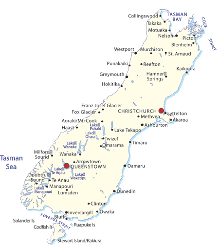
In February 2024, we were back in New Zealand, frolicking only on the South Island this time and mainly on a bike. ( For Great Walks including Canoeing the Whanganui, see NEW ZEALAND – some GREAT WALKS in 2018 , also for cycling the Central Otago Trail) We planned:
ALPS to OCEAN:5 days, biking- WANAKA: various, 3 days
- The CENTRE CYCLE TRAIL with Roxburgh Gorge, Clutha Gold Trail and Lake Dunstan trail: 3 days biking
- WEST COAST WILDERNESS TRAIL: 3 days, biking
- THE OLD GHOST ROAD, 5 days, hiking (can also be biked!)
- THE GREAT TASTE TRAIL: 3 days, biking
- ABEL TASMAN: 3-day kayaking along the coast of the Nature Reserve
- CANYONING the Torrent River : 1 day
- NZ is now also promoting itself as a cycling country with an ever-expanding network of trails, mainly OFFROAD with NGA HAERANGA (“Journeys”) Great Rides and on mainly quiet back roads with Heartland Rides, see http://www.nzcycletrail.com, also for a map of the rides. Note that a trans NZ route from North to South is already advertised as well as is with hiking – TE AOTEAROA on a bike – but this route takes long stretches still on road. For example: (done on a bus seeing those guys passing !!) a 250 km stretch on touristy Highway No 6, the only road available currently between Ross and Haast, traversing the Haast Pass… This is not for the faint hearted, rather suicidal even…! We’d rather wait until the whole offroad network is ready!!
- The landscapes of the South Island are made mainly by glaciers and diggers to turn water into power. On top you had a gold rush in the middle of the 19th century that left old rail trails and remnants of old roads that are now used for the new gold: tourism!
- The cycling on most of these trails could be called recreational: you will fully deserve your dinner each evening, but the trails are not of the type preparing you for example for joining a harder core or higher-grade amateur racing holiday. The trails should be a boon for couples that both want biking fun (or try biking fun for a first time) in amazing scenery with either the choice of both partners on standard bikes or one partner on an e-bike! So, ideal to further enhance matrimonial harmony! We both are still on standard or normal bikes and on par in cycling fitness and capacity.
- We used Cycle Journeys (CJ) for 3 rides and Central Cycling Trails (CCT) for one. One note to make when renting a bike though: request a picture and full specs of the bike to be sent to you! Some companies have little idea what kind of bike guarantees sufficient biking fun! Particularly, beware of the ones that stipulate “…. Having their own unique bike design assuring maximal comfort”!! These are usually the worst and offer discomfort in every aspect of the bike! Also, with e-bikes, we would only go for the ones that offer electric mountain bikes, the usual e-bike being road bikes: heavy, difficult to negotiate switchbacks with and erratic on the downhills!
- To our shock, we found out that rental car fees had gone up drastically since we were last in NZ. So, unlike our former 2 visits, we decided this time NOT to RENT a car and do everything with public transport (Intercity Bus is very good!) and through the occasional (private) shuttle. With the car savings we made we could spend about 100 NZD extra each day (on carrot cake, hazy IPA and Pinot Noir, mainly).
- Also, we advise buying immediately upon arrival (International) a Sim card from Spark or OneNZ (10 GB for 50 NZD is plenty for 2 months!). Always handy to be reachable when necessary for local appointments or pick ups!
OUR ROUTES (or STAYS…)
Click on underneath file for our stats on the various routes
- ALPS TO OCEAN (A2O)
A2O is currently NZ’s longest offroad cycle trail showcasing how the Island has become 100 % green power sufficient by, amongst others, connecting the emerald, blue lakes of Tekapo, Pukaki and Ohau as the Northern Waitaki Scheme and Lake Benmore, Lake Aviemore and Lake Waitaki as the Southern Scheme,
The route is about 310 km long and runs officially from Mount Cook, NZ’s highest peak to Oamaru on the East Coast. A2O is graded Grade 2 and Grade 3 (intermediate). Grade 4 is “advanced” and Grade 5 “expert”, meaning: “just get off your bike and walk when too hard”.
As an early conclusion already: you will cycle on a mix of sealed roads, single tracks, grass pathways, rough shingle roads; you will enjoy long stretches of downhill after taking in magnificent views from hilltops and passing 6 lakes in total. You will also cycle through many small towns, along pubs and vineyards and will never be too far from a warm shower and good food! Just divine!
We engaged Cycle Journeys (CJ) for three trips (A20, WCWT, GTT) helping to plan the trip, booking accommodation, renting bikes (standard Merida bikes, 9 gears. Ok) and transferring our luggage to each stop. We were very happy with their services! For the A20 we opted for the 6-day, 5 nights formula (you bike only 5 days, the first day is arrival in Twizel with briefing and bike fitting). We paid 1700 NZD pp for this package, standard accommodation.

DAY 1: FROM WHITE HORSE BASECAMP (Mount Cook Village) to TWIZEL: 75 Km, 337m ascent, 584 descent, 4h34 moving time.
The shuttle from CJ brought us from Twizel to the official starting point of the Trail. Under the gaze of a few snowcapped tops with Mount Cook sticking out in the back, the trail goes for 8 km on smooth single track to the Helicopter Base where the short transfer over the Tasman River is made. On the right side of the road you will have spotted the Heritage Hotel, the main feature of Mt Cook Village but not really leaving time to pass by for a coffee.
The Helicopter transfer is a bit of a joke, the safety briefing taking longer than the actual transfer… Note that there is an alternative (and cheaper) start: from Lake Tekapo and only 54 km long, joining the A2O after 30 km at the Tekapo Power station (see under).
The trail continues on the other side of the river on a bit of a bumpy but pleasant enough single track to a point from where you will have continuous great views over Lake Pukaki.
The carpark you are passing is the beginning of a looong dirt road used mainly by logging trucks that left their landmark feature: “washboards” (corrugated road). Luckily there are some great spots where you can go down to the Lake for a picknick or to take a rest from the road. Braemar Lodge sounds promising but is nothing more than a hidden lodge, not welcoming passersby for a stop.
After 34 km of “tediously beautiful”, the Tekapo Power station comes with an asphalt road, making you instantly happy, even on a mountain bike…..!
A roof with parasols next to it is usually a sign for an inviting terrace but Lakestone Lodge doesn’t seem to welcome dusty bikers… BUT, the trail from then on becomes fun single track, all the way to the Pukaiki Information Centre that actually doubles as a Salmon shop, offering coffee, ice creams and… salmon! (Note also the statue of the Himalayan Tahr, infamous in NZ…!)
Here you can also start enjoying (or start being annoyed by) the culture of the photographed SELF or to what lengths people go to take “arty” pictures of oneself whereby scenery is just proof of having been there; “been there, done that!”
The day finishes with a very pleasant 10km Pukaki Flats track all the way to Twizel.
CJ had arranged for us to stay in the Colonial Motel. Ok.
We had twice dinner in the Ministry of Works Bar and Eatery. Very good! There are 2 supermarkets in Twizel, 2 x 4 Square…
Note that around Twizel there is a nice River Trail of around 15 km, also touching Lake Ruataniwha. Good to try your rental bikes the day before.
DAY 2: TWIZEL to OHAU LODGE: 39 km, 150 m up, 72m down, 2h28
The first 18 km are uneventful and on asphalt but not unpleasant, following first the Pukaki Canal and then Ohau Canal. And passing a salmon farm.
From the moment you reach the lake, the rest of the ride is enchantingly pretty. Take your time and enjoy the views and the majesty of Ben Ohau.
Lake Ohau Village comes on your left after you hit the road and not worth exploring. A further 7 km brings you to the wonderful Ohau lodge, beautifully set on the lake’s edge looking towards the mountains. “This retro style ski lodge, with full dining & bar facilities, has a cosy shared lounge complete with open fire. The large sundeck (“sundick”) offers expansive views and is the perfect place to relax with a drink and recall the days adventures.”
A great place to end and start wonderful days, indeed! ((a wonderful) dinner and ditto bf are included in the CJ package!)
DAY 3 OHAU LODGE to OTEMATATA: 77.5 km, 828m ascent, 1118 m descent, 5h33
Note that this is a long day. When going for the 7day-6night option, this is a 2 day ride (42 km to Omarama with 369m ascent) .
But it is the most exciting day with lots of cycling fun and in amazing scenery!
Leaving the Lodge, the first 6km are easy and a warmup. The climb thereafter (about 300 m ascent) comes in the next 6 km, gradual, the pace only slowed down by the often-rougher surface than by its inclination! Before you break lots of sweat, the high point at 900 meter is reached, with good views!
The next 8km is an exhilarating downhill!! Fun, certainly on a mountain bike, till the “Historic Woolshed”. Qualborn Road comes as a somewhat undulating dirt road, almost all the way to Omarama. We didn’t make the turn to the Clay Cliffs (we heard worth the detour, but the road not being pleasant…).
Busy Omarama is good for a stop, lunch and coffee! And certainly, to load up on water for the second part of the day when hot!
A2O brings you then safely and on pleasant trails passed Chain Hills and along Lake Benmore – bypassing as such SH83 Road- to the Sailors Cutting campground which you go right into, traverse and come out at the edge of the Lake. From here, a magnificent stretch both in landscape and cycling fun – grade 3 – of 16km follows along narrow gorges connecting the waters of Lake Benmore and coming out at Junction Island and finally climbing to a viewpoint with great views of Benmore Dam and Otematata in the distance. “FENTESTIC!!” as the locals would say.
Some single track, a fast downhill without crossing the dam plus some more single track along campgrounds bring you then to the town. (We didn’t realise that the next day we had to go back up as a start of the day and cross the dam….).
CJ arranged Waitaki Lakes Apartments for us, coming with a Far West like Pub and Restaurant, Otematata Eatery. All good! Our apartment had the golf course as garden terrace, great for a drink and breakfast! (bf included in the package)
DAY 4: OTEMATATA to OTEKAIEKE (Windhaven B&B, 7 Km from Duntroon): 63 km, 360m up, 430m down, 3h26
The day starts with bringing you back where the day before ended with more fun … A good warm up all the way to NZ’s largest earthen dam – and the second biggest generator of hydro power!
Undulating sealed, quiet but scenic road littered with quite a few dead wallabies brings you to Aviemore Dam at 28 km. A dedicated offroad single track first along Lake Waitaki takes you then to Kurow, a further 16km. Note that about 5 km before Kurow, A2O managed to put in a fun-tastic last few km trail into town.
Take time to have lunch in Waitaki Braids Bakery, on the back terrace or coffee in the front!
From Kurow on, the route continues offroad, along, over and passed rivers flowing into the Waitaki River … but most were dry at the time we passed… You also cycle through some vineyards, belonging to River T Wines. A stop is optional.
After having passed the 3rd river (Otekaieke) you will soon notice an oasis with waving flag above along the road: Windhaven B&B, a lovely address in a tranquil garden. Michelle and Steve will make you feel at home immediately and pamper you accordingly! (Wonderful dinner and wonderful bf included!)
DAY 5: OTEKAIEKE to OAMARU: 64km, 557m up, 717 down, 3h47
The last day but not an easy going one! It is until after Duntroon which looks as if its heydays are over now… A climb next to an asphalt road with soon a sign for “Elephant Rocks” marks the beginning of some hard work…! You can get off your bike to have a look at the quaint rock formations… continuing then through an interesting gully along identical boulders, finally bringing you up by testing your technical cycling skills in a few switchbacks.
A single track along a large pond will at the end bring you up to a dirt road… and further up and up.. to when you reach “Peaks Road” at a T-junction and seeing the Ocean in the background.
The worst is over by now, even followed by some smooth downhills to Windsor after you have gone through the tunnel. Enfield has a very inviting-looking restaurant for lunch or coffee: Fort Enfield Tavern. You will need it to bring you to Weston, on a tedious and often “false flat” road, with headwind when unlucky, along a main road with some ugly industrial structures. But soon the route is going down to Oamaru Public Gardens and then to the Ocean, at Friendly Bay, the finish.
We should have stayed the night in Oamaru! The town has a distinct feel, certainly its Victorian Historic Precinct where you expect Charles Dickens himself to pop out of one of the warehouses. Further along the beach, you apparently may also find a blue Pinguin colony…
CJ is in one of the warehouses, impressively well organised with coffee, changing rooms and space to cool down (or warm up).
Instead of staying, we sped off to Wanaka (with Door2Door, for 450 NZD)
2. WANAKA
Well, we didn’t really do a route here, but we just wanted to take up Wanaka as a destination in case you didn’t plan to go there!
Things NOT TO MISS:
- 1 Day: Bike from Hawea Lake (you can first do the Gladstone track along the Lake in the opposite direction, then come back, i.e 2 x 8 km, and then continue…) along the Hawea River via Albert town (having lunch in Pembroke Patisserie is a must!!) along the Clutha river and its Outlet (inlet) from Lake Wanaka, passing Roys Bay (Wanaka) along the Wanaka Tree, to Waterfall Creek (all grade 2). Optional: further to Glendhu Bay, grade 4 (but will become grade 3 within a few years, so we were told) … We did this with James of www.NZbiketrails.co.nz (They also do Lake Dunstan, and a few more!) They rent standard Trek mtb. You can book them and you are picked up at i-Site in Wanaka. Good! A beautiful day!
- Alternative to 1: walk from Roys Bay (Wanaka) along the lake passed the Marina, Bremner Bay, Peninsula Bay, passing the Clutha River outlet all the way to Albert town. This is a magnificent (flat) walk! After lunch in Pembroke Patisserie, hitchhike back to Wanaka.
- 1 Day: Roy’s Peak, Wanaka’s Instagram hit. But we must admit, worth doing! (Wait for a clear day forecast!). You can book a taxi with i-site (30 NZD/PP) to the start, a 10-minute ride along Mt Aspiring Road and hitchhike back! Most people only go up to “Instagram point” with amazing views of Mt Aspiring and Lake Wanaka which is at about 1200m altitude. The very top comes after 7.7 km and ascent of 1267m at a height of 1583m, so 13% elevation on average… moderate!!!! We did it in 2h06, all the way up!
- Just watch people taking pictures at Wanaka’s tree. Hilarious! Also, at Roy’s Peak..!

Recommended restaurants in Wanaka: Relishes Café for lunch: solidly good! Francesca Italian: great Pizza! Paloma: upmarket Mexican, good but they think therefore they have to serve small portions. Wana-fusion: a bit of everything Asian but at the end undefined, but cheap(er).
3. CENTRAL CYCLE TRAILS (CCT)
We call this the Central Cycle Trails as we did it with the eponymous organisation (CCT). Similar as with CJ, they are an organisation taking care of luggage, shuttle people, do your bookings. Very Good (but no good standard bikes!!! “own design bikes guaranteeing maximum comfort…” ). Package: 1050 NZD per person
DAY 1: THE ROXBURGH GORGE: From Clyde to Roxburgh: 45km, 571m ascent, 651m descent, 3h09 moving time.
An enchanting start from Clyde to Alexandra on a river trail becomes rustic and rather lunar from then on. Also, Grade2 becomes Grade 3. At Doctor’s point but in the middle of nowhere, you may wonder whether there will be a ferry at all… Until heavy roaring from jet engines is approaching…
Hopefully Dave will be your captain for a hilarious transfer. His great grandfather came from Scotland at the age of 14 to dig for gold. It stayed in the family, this activity, but Dave is now digging for other gold. He will show and tell you how they found gold deposits, where people and how people “lived”, geologically interesting points, who deposited the gold, etcetera… This all coming without subtitles in a juicy Scottish accent… And ending with a 360 degree spin before landing!
The next part from Shingle Creek till Lake Roxburgh Village is the most beautiful part of the day but requiring some work! Once you have crossed the dam, it is all downhill entering a green valley with totally different scenery and well-maintained fruit orchards.
Roxburgh comes again with a distinct Far West feel…! The Great Tavern is worth a visit and actually the only place where you can sit down for a meal! Enjoy the local scene and the juke box!
The Roxburgh Motel where we stayed was very good, coming with fruit and chocolates, and a whole bread and 6 eggs for breakfast.
DAY 2 THE CLUTHA GOLD TRIAL or from Roxburgh to Lawrence: 65 km, 454 m climbing, 420 m downhill, 3h44
A stunning day along the Clutha River with smooth cycling and mostly easy downhill all the way to Beaumont! “After each bend you will discover a different landscape” and the Clutha River will show its varied wonderful appearances! Enjoy this ride thoroughly with regular breaks! Don’t forget to take the little detour to Horseshoe Bend Bridge.
You leave the Clutha River at Beaumont and thus also leaving the most beautiful aspect of the ride. Most of the climbing of the day still has to be done, then. But it comes gradually on a former railroad and luckily going through a tunnel at the highest point. A smooth downhill and Evans Flats take you into Lawrence, another quirky little town as so many in Otago…
We were picked up at the Prospector (try the Wild Walnut instead for lunch!) and shuttled to Clyde.
CCT arranged there for us to stay at the Post Office having 3 rooms in the very former post office living quarters (only one is with ensuite bathroom, though), cutely decorated as of yesteryear. They also have a very good restaurant, a bit disorganised but friendly enough to make up for it; book a table in the former postal office! Or in the garden when not too windy..
DAY 3: LAKE DUNSTAN GORGE or from CROMWELL to CLYDE: 39.54 km, 710m ascent, 756 down. 2h48
A must do trail with good but quite tough biking fun! (when having a good bike, that is…!). We were shuttled from Clyde to Cromwell (that is a bit of a bummer as you can see already where most of the trail is running…).
The ride starts in Cromwell (“capital” of Otago, the city with the statuesque big fruits) and makes a loop around the Kawarau river, even taking in the inlet of Bannockburn and going up to Carrick Winery, too early for lunch, but good for a coffee and great views!
From Cornish Point, the ride becomes interesting! On single track, often on hanging platforms just above the water, or over high suspension bridges, often hard to pass opposite coming bicycle traffic, often grade 3, hard work when headwind, but ALWAYS in fascinating scenery and on interesting trail.
In a small inlet just before Cairnmore Ladder, you may have to fill up on some energy because the Ladder immediately afterwards comes as a wall of a straight 110 m ascent just over a few switchbacks. The saddle immediately after may still have you working hard if the wind is against you…
Halfway Hut in turn requires another 80 meters up but its downhill is fun, again! But don’t go too enthusiastic on this one now after feeling you could have done the first one faster…?!
The rest of the trail remains fun, particularly after the Dam.
Clyde has no major road running through it and remains picturesque with some well maintained facades. They house amongst others the Dunstan Hotel, Oliver’s restaurant and The Post Office.
CONCLUSION CCT: Great rides! Ideally you do Luke Dunstan first and then continue the Roxburgh gorge and finish with the Clutha Gold trail. And: be sure you have a sufficiently good bike!
4. The WEST COAST WILDERNESS TRAIL (WCWT)
The official website states: “Dramatic natural and human history is revealed around every bend on this Ngā Haerenga Great Ride of New Zealand retracing old packhorse tracks, tramlines, railways and goldmining water races – now connected with new, flowing singletrack.
Taking in the historic towns of Greymouth, Kumara, Hokitika and Ross, it offers deep immersion in the Coast’s world-famous scenery as well as a journey stretching back in time to the Māori pounamu (greenstone) and the gold rush eras.”
We decided to cycle from South to North (planning to take the NZ Alpine Train to Christchurch at Greymouth, shortly after arrival there!): so CJ booked us in Hokitika where we picked up our bikes and were then shuttled to Ross. (800 NZD pp package)

DAY 1: FROM ROSS to HOKITIKA: 38km, 2h09, 150m up and 200 down.
Just a lovely afternoon!! (we arrived late in the morning in Hokitika from Franz Josef on the Intercity bus)
The trail has an interesting start in Ross which we celebrated with coffee at the 1864 Hotel! You soon follow the ocean (you only hear it) on a former railway through leafy marshland with plenty of traces of gold-digging activities or related works from that era. After about 14km you hit Highway 6 which you go down on for about 1.5km, turning left soon after and reaching the Treetop Walkway.
CJ had booked us a ticket to visit. Enjoyable and informative, coming with café and terrace.
The trail towards Hokitika afterwards offers pure biking fun rolling on former tramways through pleasant forest.
Also, the arrival at Shipwreck memorial in Hokitika and the last kilometres along the beach are wonderful and therefore already worth the ride!
CJ had booked us in Jade Court, a well-run and comfortable motel! (bf included)
We had dinner (and enjoyed sunset) on the terrace of the Beachview Hotel restaurant. Good!
DAY 2: HOKITIKA to KUMARA: 71 km, 4h46, 730 m ascent and 645 m descent
This is a long but phenomenal cycling day, thanks mainly to the gold-diggers who needed racing water to wash their finds and therefore built amazing networks of water channels/canals through the mountainous forest! Today you will cycle a good part along these!
The day and the distance cannot really be split up as Cowboy Paradise coming just at halfway has much less to its name than in reality…! It doesn’t look inviting at all, actually grim and dingy. Even the website of WCWT warns not to pause there and sit on the terrace… When passing, we were happy not be booked there (and as such it would have been a 4-day, 3-night package!)
The route takes you first along the Hokitika river and some new and old industrial buildings till Kaniere where some fun trails – like the former tramways of the day before – bring you in higher spirits. Until you hit the road and a decent warmup to Hurunui Jacks (12 km) comes up.
Climbing forest tracks bring you then to Lake Kaniere (at 21 km) where you continue going up through forest, reaching a high point from where you start seeing pastureland. A rather steep downhill brings you into the Milltown valley passing some farm buildings and soon reaching the river (Arahura) coming with a “shelter” at Milltown.
Here you can have a walking lunch (or “break dancing” rather) as sandflies are looking at you as their lunch!
On purpose laid out switchbacks will bring you then gradually passed Cowboy Paradise, further up to and through (hopefully) low water weirs and finally up to Kawhaka pass (at 330 meters the highest point of the day).
From then on it is mainly downhill (with some “false flats” still), over and along a reservoir and a final stretch through forest to Kumara. This town comes with fully restored goldminers’ accommodation, The Theatre Royal Hotel, dating back to 1864.
In addition to the Hotel, some motel rooms were added.
Pre-book your table (send a mail to the hotel in the morning!) at the restaurant for a good meal in a quirky but surprising setting! (no other dinner opportunities in town!)
DAY 3: KUMARA to GREYMOUTH: 28 Km
The first 10 kilometers till Taramakau across forest and over suspension bridges offer still some thrills but soon the trail becomes uneventful, even tedious all the way to Greymouth which forms a bit of an anticlimax as arrival… We didn’t take the turn to Shantytown as for once – only this morning during our whole 5 weeks! – it was raining… We should have, though!
The first glimpses of Greymouth station and Speights Ale House look somehow promising, but the further you go into town the more you feel that Greymouth is a great town….to get out off.
This is not fair to the people of CJ and their depot where again we received a warm welcome back!
We did something quite original, we think: we took the 14.15h NZ Alpine train to Christchurch and came back on the same train the day after…. A rather advisable alternative to having to spend 2 nights in Greymouth… The weather was terrible to CC, but clear and blue skies going back. Worth the while!!! (but not cheap: 265 NZD one way pp.)
So, we stayed one night in Greymouth, in the Sundowner Motel, more in name than actual. But comfortable rooms… And had dinner in the only oasis in town: Seven Pennies Restaurant…
Conclusion for WCWT: day 2 makes it really worth it!!
NOTE: look into the new PAPAROA track from Kaiteriperi, also on the menu of Cycle Journeys!
5. THE OLD GHOST ROAD (OGR) – WALKING
The 85-km long OGR follows in the footsteps of old gold miners on two rediscovered trails, winding up and over the mountains, traversing majestic native forest, open tussock tops, river flats and forgotten valleys.
Your appreciation for the trail will be further enhanced by knowing how the trail came into being:
During the West Coast Gold Rush in the early 1860s, the town of Lyell on the Buller River was founded. A dray (a low, flat-bed wagon without sides) road was built at the time towards the Lyell Saddle to give access to several mines and gold towns.
There was also a dray road that started south of Seddonville and went along the Mōkihinui River. In 1886, a survey was carried out to connect these two routes. Over time, knowledge of how much of the route had been built has been lost and the slips and landslides caused by the 1929 and 1968 earthquakes caused further damage.
In 2007, Marion Boatwright and his wife, builders and owners of the Rough & Tumble lodge were handed the original of an 1886 survey plan for a “Lyell and Mokihinui Road”… That was the spark for Boatwright making him the driving force behind the establishment of the OGR as a tramping and cycling trail. This fascinating story can be read in “Spirit to the Stone, the building of the Old Ghost Road” written by Boatwright and of which a copy can be read in each of the huts on the trail and can be bought in the Rough and Tumble Lodge.
The Road opened officially in December 2015.
We shuttled from Greymouth to Lyell with Go Tracks – West Coast Mountain Bike and Tramper Shuttle Service
The only thing remaining of Lyell, once a town with 1000 inhabitants is a hut with mesh as windows to protect you from sandflies while changing onto your walking gear…

DAY 1: FROM LYELL TO LYELL SADDLE: 17 km, 629m ascent, 182m descend, 4h09.

A very gradual climb on gravel track often in enchanting forest brings you up. Quite a few goats roaming around during the first stretches made us wonder whether the trail was misnamed and should have been “Old Goats Road…?!” Also, fantails and robins were happy with our presence; and we spotted a Kaka.
Passing the Big Slips gives you a view over a magical canopy rolling till the horizon, a mesmerising sight which will come back often over the next few days. But the slips remind you as well of how fragile the trail you walk on actually is…
Lyell Sadlle was the first hut built by Boatwright and his courageous buddies. 12 bunks and enough amenities to have a sheltered night (good to know: only the kitchen bunks remain warm during the night!)
DAY 2: LYELL SADDLE TO GHOST LAKE: 12km, 562m up, 236m down, 1340m highest point, 3h01.
You are passing the treeline at about 1200m but still going up. Dramatic views start from Top Camp shelter with range after range of mountains as far as the eye can see. The very top comes after the 2nd Bluff; Rocky Tor offers an Instagram rock point but only when weather permitting…! After knocking on Heaven’s door, you keep rolling towards Ghost Lake hut (at 1222m altitude), the most magnificent hut of the OGR both in views and in layout (18 bunks).
Hopefully the weather is good enough allowing to while away on its amazing terrace seeing where you will be going the day after and how mountain bikers are tackling the road ahead.
Hopefully there will not be a guided (biking) tour group that evening spoiling the calm of the place and taking over the hut with ever-jollier conversations infused by helicoptered-in-wine, more than frequent toilet visits during the night and spoiling your morning with nervously questioning the guide….

DAY 3: GHOST LAKE TO STERN VALLEY: 12km, 130m ascent, 964m down, 395m lowest point. 3h17
What a start of the day! And this all the way down the steps at Skyline Steps! Don’t forget to look back from time to time to marvel at the location of the Ghost Lake hut! And imagine what a thrill cycling on the Skyline Ridge would give!
Note that the Trust behind the trail is looking into building a track which would avoid doing the steps.
A pleasant descent all the way through forest will bring you to Stern Valley Hut.
Note that a short path leading to the Campsite behind the Hut brings you also to a river with some rockpools allowing you a rejuvenating plunge! Some phio (blue ducks), always seeming to come in pairs and feeling comfortable with your presence, may draw your attention away from dipping under to avoid the sand flies…
DAY 4: From STERN VALLEY (395m alt) TO SPECIMEN POINT: 25km, 502m ascent, 747m descent, Highest point: 695m. 6h05.
The longest day. And as dinner you will deserve a double portion of your “dehydrated something but no matter what always tasting like salty bean curd bits with some undefined gravy” …! (all words should be with a – in between…)
The Boneyard comes in an-other-worldly, moon surface like valley with a looming stonewall in front of you, one that didn’t come down during the last earthquake… This will make your climb faster to leave the Valley at the highest point of the day, going down then towards Goat Creek without noticing any remaining whiffs of the hanging judge.
From Goat’s Creek on, the walk following the river becomes really enchanting; squawking parrots give it a jungle feel and colourful mushrooms show off their toxicity…
Mokihinui Forks contain some remnants of a washed away bridge and apparently also some airplane bits floating around…?!
Specimen Point Hut comes again with a wonderful terrace with great views over the river.
A little walk down from the hut along the trail gives you again a dip-opportunity.
DAY 5: from SPECIMEN POINT TO SEDDONVILLE – ROUGH & TUMBLE Lodge: 16.8km, 3h48 278m up, 378m down, highest point 144m, lowest 33.
A perfect trail to finish off: all along the amazing Mokihinui river proving all the facets of how beautiful a river can be and when through forest, with the same feel as the day before: lots of birds, fairytale like atmosphere and… magic mushrooms!
The finish doesn’t have the sheltered-from-the-sandflies changing room, though.
A bit further up the road you have the lodge which comes really with a yesteryear lodge feel. Again, we should have stayed the night, probably to celebrate the achievement and to stay a bit longer in the rather “magical” OGR ambience…
We had lunch (something called “pizza” but that was a violation of the name) and a coffee there; by then our shuttle to bring us to Nelson had arrived (Go Tracks, 800NZD for the shuttle. While staying in the huts at OGR is still a bargain: 40 NZD pp per night.)
CONCLUSION OGR: a must do! Great off-the-beaten-track (still) with stunning views and feel! The way we did it was perfect: 5 days, 4 nights. (They may put in an additional hut between Stern Valley and Specimen Hut, not necessary but the trail will grow in popularity, for sure, both for hikers and bikers.)
Note: I am trying to convince Kobi to mountain bike the OGR trail. It is simply magnificent!!! The bit between Top Camp Shelter to Heavens door is a bit scary and coming as grade 5… but walking your bike looks more than ok. As is with the stretch before Skyline Steps. But the rest of the trail is just PURE FUN!!!! I would suggest biking the trail in 2 days and certainly starting from Lyell (allowing a gradual ascent) and staying in Ghost Lake Hut. After finishing, stay a night in the Rough & Tumble Lodge! Enjoy!
6. THE GREAT TASTE TRAIL (GTT)
In Nelson we stayed in the surprisingly good and friendly Tasman Backpackers Hotel (Weka Street)! They have 1 ensuite double room (95 NZD) and quite a few double rooms with shared bathroom. Recommendable restaurants in Nelson: Urban Oyster Bar and Eatery, Arden Bar and Kitchen Restaurant, for lunch: Bobby Franks Café.
The official website of Great Taste Trail reads: “…get an extraordinary taste of all Nelson Tasman has to offer…, experience the region’s towns, ride past orchards and vineyards, sparkling coastlines, rivers, and hill valleys. It’s called The Great ‘Taste’ Trail because of the incredible diversity of experiences you sample along the trail.
You will traverse the edge of internationally significant coastal estuary systems, home to several rare bird species. Meander along Rabbit Island’s beach front, and drink in spectacular views of the coast, the mountains and Tasman Bay…”
We picked up our bikes in Cycle Journey’s (CJ) Nelson’s depot (1000 NZD pp package) and got on the trail right away.

DAY 1: FROM NELSON TO TAPAWERA: 69km, 548m ascent, 405m descent, 4h15. Highest point: 314m
The route with GTT signage manages to get you out of Nelson in a safe and interesting way via the Railway Reserve Route (come back via the Coastal Pathway). Hope, the name of a village or crossroads on Highway no 6, lives up to its name as there you turn right and start to get a feel for the agricultural importance of the region cycling along vineyards, fruit orchards, greenhouses and hops fields.
Brightwater offers a first stop with bakery and Ernest Rutherford’s Memorial (a must! Without him no Oppenheimer…). Next stop (for lunch): Wakefield (the bakery there is overhyped: lots of choice but few fine pastries nor other fine savouries. Try the Villa for lunch on a nice garden terrace).
After lunch you pass on your left quite a few layer farms with “outrun” before you start the good 4 km steady ascent towards Spooners Tunnel. This comes as a welcome intermezzo after which some very enjoyable downhills follow, all the way to “Flat Rock Café” for an ice cream or coffee. The last 8 km still offers Sculpture Garden as an interesting stop: quirkiness in nature. Enjoy the quiet and calm!
Tapawera will bring you again in a Far West mood. Interesting stop with comfortable stay.
DAY 2: TAPAWERA to RI(U)WAKA: 68km, 436m up, 533 m down, highest point: 293m. 3h54
A day along the Motueka river, except after crossing Wangapeka river and bridge, where you have to climb a rather 3.5km (not 2 km!) dirt road mainly used by logging trucks to a saddle at 293m altitude. A fun downhill on the same road brings you to Baton River where a DIY honesty- coffee and drinks await you. An often corrugated and on coarse pebbles larger undulating dirt road leads to a car dump, Woodstock from where asphalt takes over – happy for once to be on sealed road again…!
A swing bridge then brings you over the river, purposely taking you to River Haven in Ngatimoti, a vineyard cum wonderful outdoor and indoor restaurant place but not devoid of any modesty: the label on the bottle names itself the “most beautiful vineyard” in NZ; and telling from the numberplates, the 2 Aston Martins (“Mr” and “Mrs” ) in between the oldtimers are clearly of the owners, “his” and “hers”… Call it positivity, not hubris…?!
We were supporting the poor souls with a 45 NZD pp pre-booked lunch… (included in your package..!!??)
Another 18km on the other side of the river brings you first to Brooklyn and then to Riuwaka with on the way plenty of fruit and other honesty fruit and berry- stalls. Terraced Chalets will make you arrive out of breath, and not only because of the lovely and peaceful look of the place… Jane will welcome you; John will drive you to Riwaka Hotel for a nice dinner (prebook in the morning! no other eateries in Riwaka!)
DAY 3: RIWAKA TO MAPUA (with detour to KAITERITERI): 60.35 km, 540mup, 549 down, 112m highest point, 4h19
Just a PERFECT day!!
We decided to add Kaiteriteri to our route which makes the day a bit under 20km longer. This is very recommendable but just be aware that the last kilometres are on a dedicated mountain bike trail rated as “easy rider”. This should be no problem if you feel comfortable on your rented bike! The single track is smooth with some sharp little climbs but always staying under 10%, narrow at times so you will need to have your presence known before every blind bend…! The alternative is the road to Kaiteriteri which is also narrow and very busy and no fun at all!!
In Kaiteriteri you are rewarded with splendid views on beach, sea and islets that all can be sampled with a coffee in hand! You will have to tear yourself away to continue the ride. But after the bridge on the main Highway, the route luckily turns away from Motueka and continues along the sea, just wonderful all the way to Toad Hall (after you cross the main road coming out of Motueka!) where you can refuel (shop for lunch in a local specialties outlet or sit down for lunch at the restaurant terrace!)
After lunch you continue to Low Motuere where at the school the last real work for the day starts…! The GTT leaflet rates it as a grade 3 for about 2 km. At the highest point a shelter tent offering shade has been erected enjoying views over the Tasman Valley on one side and over orchards almost rolling into the Tasman Sea on the other.
Some great downhills pass along Ruby Bay (without actually riding along the beach) finally ending up in Mapua. Here, we were housed again uphill in “For puffed pedallers”, a charming B&B.
After your shower you could step in Sprig and Fern, just down the road for an impressive array of beers on tap but go a bit further to Mapua Wharf for a better choice of food.
DAY 4: MAPUA to NELSON: about 28 km, easy.
Head down to cute Mapua Wharf for a coffee before the 2-minute Ferry ride to Rabbit Island. An easy ride on unsurfaced trails and tracks parallel to the beach leads you further into an estuary and finally towards Richmond. Once you have hit the huge papermill, the best of the day has passed.
After this, take the Coastal Pathway this time, but at a crossing just before the airport leading you under Highway 6, take the Railway reserve Route again (the booklet is unclear about this!) and NOT the direction to Tahunanui (which is the port of Nelson, reachable on a bicycle path sharing most of the time the car lane…!) Hopefully the road works have been finished when you pass, and the signage has been restored.
Leaving the trail for a short distance before you go under the Highway, for once a Classic Car collection may give you some thrills and this after a restaurant that comes with the name of “honest lawyer” …
After your visit, retrieve your tracks for a short distance and try to spot the Signage for the GTT. Soon, you will reach CJ’s depot where you started.
CONCLUSION Great Taste Trail: very, very enjoyable and thus recommendable, fulfilling all the promises the booklet state! We thought it felt like a “discover-the-other-New Zealand” experience…
7. ABEL TASMAN CLASSIC KAYAK TOUR: 3 days
Abel Tasman Kayaks (ABK) is offering a three-day “adventure” at 1000NZD pp.
The website of https://www.abeltasmankayaks.co.nz/ describes it perfectly: “Immerse yourself completely in the natural wonders of the Abel Tasman National Park. Be wowed by the night sky, the milky way is truly amazing in the park. Enjoy drifting to sleep listening to the waves before waking up to bird song. It’s a relaxing, content-rich, fully catered, beach side camping experience.
Spend three days kayaking the coastline from beautiful Totaranui/Awaroa in the North down to the golden shores of Marahau. Spacious and spectacular, the northern section is seldom visited by others. The middle of the park offers lagoons and rocky outcrops. The southern section showcases twelve stunning beaches to end your journey.”
You sleep on the beach in comfortable tents provided by ABK (when lucky the tent will have been put up already when you arrive!) coming with good mattresses! The kayaks are very seaworthy and practical; kayaking is easy: mostly with surf and wind pushing you already, the food and drinks are good and plenty, going towards glamping rather than camping….And Whitney was our fun and resourceful guide…!
And most important: NATURE IS STUNNING and coming as well with playful seals, majestic cormorants, skittish stingrays and weka rascals….. In brief: A really COOL and FUN experience!
8. CANYONING THE TORRENT RIVER
To be sure we had enough thrills during our 5-week stay, we decided to end our holiday with a 1-day canyoning trip on the Torrent river. See https://www.abeltasmancanyons.co.nz
