
By bike from Salzburg to Trieste and back via Slovenia
From August 31 to September 15, 2026
The Alpe Adria is a popular cycling route starting from Salzburg and ending in Grado on the Adriatic Sea. Officially it is 410 km long with a positive elevation of about 2400 m. From Grado you cycle back or take a shuttle.
Paul Benjaminse’s cycling guide “Salzburg to Venice/Istria” (In Dutch only) offers an attractive variation on this: a loop from Salzburg via Zell am See to Villach, Tarvisio and Venzone, from there to Cividale del Friuli and via Gorizia (Nova Gorica) to Trieste; then back on the same road back to Tarvisio via Cividale to Kobarid, Tolmin, Bled and Kranjska Gora and in Dorfgastein (Lend) via Bischofshofen to Salzburg. About 850 kilometers through Austria, Italy and Slovenia and 6000 m difference in altitude. (see map)
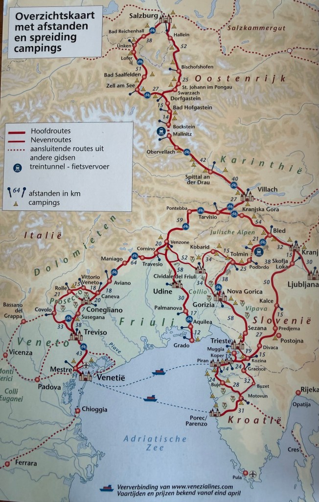
We could also have gone back from Trieste via Postojna and Kranj, but we definitely wanted to cycle via Kobarid and Tolmin because we will start our Transdinarica trip there next year.
Paul Benjaminse offers you on his website www.cyclingeurope.nl also perfect GPX tracks of the route!
Note that we measured the stages with three different bike computers (Wahoo, Coros and Garmin). Interesting to see how much difference there can be between them and even between the same routes measured on the same device… (there and back) … See our route stats:
You will also sometimes notice a clear difference here with what you get to read on the GPX track before you start…
Below we will give an average of the 3 devices in terms of climbing and descending.
We made the trip on our Stevens gravel bikes, with a small backpack for cycling gear and a saddlebag for the evening dress…
Before our trip, we spent 2 nights in Salzburg; see the Conclusions for some recommendations in and around Salzburg. We stayed in Pension Herbert for 158 € per night including breakfast. Good!
DAY 1: SALZBURG to SELL am SEA: 89km, 853meters up and 523m down, 04:45h
The official Alpe Adria route runs via the Salzach to the south but before Werfen the route has to squeeze itself for about 8 kilometers through a valley together with a train route, highway and local main road. This means sharing that local main road without a cycle path with some crazy local cardrivers and with quite a bit of climbing to reach pass Lueg.
A pity, because the beginning of the route until just after Golling (at 25km) goes very pleasantly through idyllic alpine meadows or along the Salzach and through attractive Hallein. After Werfen you again mainly follow the river, but not always in a pastoral setting…..
According to Benjaminse, the route via the Saalach river and Zell am See, although 37 km longer, is more beautiful. And we agree with that!
So at the Salzach in Salzburg, at the height of the Kaietanerplatz we took direction “Mozartweg (Mozart Cycle Route)”, so southwards, into the city (The Alpe Adria goes straight on, so eastwards, following the river).
You will notice that the GPS quickly exchanges that route for the Tauernradweg… (We followed the various GPX tracks flawlessly until they brought us safely back to Salzburg 15 days later!)
You leave city nuisances like highways and an airport quickly behind…. you enter Germany and you continue to follow smoothly the Untersberg Mountain range on the left (see conclusions re Salzburg) until after Bad Reichenhall after which you hit the Saalach for the first time. When we entered this town, it felt like we cycled into an open-air senior home, among residents enjoying a coffee and each other’s presence in the sun.
The route stubbornly keeps on following the Saalach, not always the easiest way to keep going south.
We had lunch at Lofer at Stoaberg Café on their lovely terrace! Highly recommended, also because most of the elevation gains are still to come.
On our way we had already seen signs that pointed to works on the Tauernradweg between Weißbach and Saalfelden with even “gesperrt” on it (“blocked”). We decided to do just like we aways do in France: ignore them completely. Oncoming bicycle traffic reassured us the road was open…!
After some ingenious navigating through and around Saalfelden, you go rolling – this means getting enough speed down usually takes you a good way onto the next hill already – past Pfaffing, Gerling and Maishofen. And this until you literally bump onto Lake Zell! What an entry!
We stayed in the Glaserenhaus for 145€ with breakfast. Good! And dinner in the busy Kupferkettel restaurant. Good!
A serious thunderstorm kept us from a walk before and after dinner…
DAY 2: ZELL am SEE to MALLNITZ: (From Bad Hofgastein to Bad Gastein: taxi; Bockstein to Mallnitz: train): 50km, 598m climbing, 436m descending. 2h40
You leave Zell quietly and beautifully with the lake still to your left. (Zell deserves a holiday on itself!) The peace and quiet is soon over and from Hogmoos it becomes quite noisy due to the presence of national road 311 with which you share the valley … The route builders kept it safe by letting you continue above, under and beside the road.
Just before Lend come a few stingers taking you through two tunnels. The second one is 1.6km long and when a traditional electric bike, usually dressed with extra mirror(s) comes your direction, be careful because the bike path is tightly sized… (and those cyclists often don’t look very confident on the bike…!!).
Once through the tunnel you enter the Gastein Valley. And soon passing Gasthof Klammstein where a deserved coffee can relieve the noise and stress of the tunnels.
The route is a bit monotonous along or off the main road with only Dorfgastein as a charming town.
According to the guide, we could take the post bus or a regular bus in Bad Hofgastein to avoid the steep ascent to Bad Gastein. So we cycled to the bus station there… to hear from the bus drivers that they no longer take bicycles… We had already set our mind on it, so we decided to take a taxi to the station of Bad Gastein….
In retrospect (after cycling the way back) we would do the climb…! But it’s definitely not an easy one: count on 2 very sharp inclines!!! The alternative now to avoid the climb is to take the regional train in Bad Hofgastein (see Home – ÖBB)
We got a very good first impression of Bad Gastein and decided to stay there for the night on our return!
The last part from Bad Gastein to Böckstein follows nicely the Gasteinache with an Irish pub (The Irish Coffee) just before the still serious climb to the station!
We got in and out of the tunnel and to our sleeping place in Mallnitz: Mallnitz Apartments and restaurant run by a Hungarian couple. 110€ with breakfast. Ok.
DAY 3: MALLNITZ to VILLACH : 86 Km, 458m ascent, 1134m descent. 04:21h
According to the map you are now in Carinthia cycling along the Drau and this to Villach.
You start the day with a beautiful descent. Stay on the main road until you reach Obervellach! The route or GPX sometimes make an attempt to go off the main road, but that is more dangerous than staying on it! There is not much traffic on it anyway!
After Obervellach, cycling is smooth like the Drau where dams take most of its current away. We had lunch in lively Spittal in the enjoyable Konditorei Moser where we also marvelled at their choice of cakes…!
Without much further ado we reached Villach. The town charmed us more than what we had read about! This may also have been because of the surprisingly good Palais 26 hotel! 156 € with breakfast. Very good!
DAY 4: VILLACH to TARVISIO: 33 km, 404m ascent, 167m descent. 02:18h
You leave the Drau and cross the city to the Gail which you follow quietly for quite a long time until you reach a bicycle bridge over it…. which was closed off! It took us some effort to find the right way back. Apparently, good signalling at road works is a problem everywhere – and this certainly for bicycle traffic…!!
In Neuhaus you join the N83 taking you to Italy on a bike path next to it. The busy traffic has already turned off the N83 a little before the border; as a result, you have the road between Austria and Italy almost to yourself! By following the GPX only in Coccau do you leave the main road and follow the directions Slovenia and Tarvisio! This reduces some steep climbs.
Just before Tarvisio, you are made aware of a confluence of several cycle routes and of a location on a three-country divide… And the Triglav appears on the wallpaper…
“Upper” Tarvisio, just above the cycle route, is quite pleasant and appealing! Some chic brand stores even try to give it a mundane feel. There is also a cozy square (Piazza Unità) with a beautiful view on the Triglav, Slovenia’s pride.
We stayed at Hotel Raibl for 134€. Good.
DAY 5: TARVISIO to VENZONE : 57km, 172m climbing, 674m descending. 02:27h
The GPX indicates an elevation of 654m today… No idea where these meters comes from?? In Tarvisio you start with a sharp little slope but in Camporosso the calves remain only slightly warmed up. But our own bike computers were also going rather wild today…! (see the elevations for today in the excel sheet)
Anyway, today is a blissful day on the bike: it felt like a 50 km continuously leisurely descent on a stunningly good bicycle highway in spectacular surroundings with the occasional inviting bicycle café along the route – in Chiusaforte and in Resiutta – to celebrate your enthusiasm! It is getting noticeably warmer, though; you feel the Mediterranean coming closer…
Only in Carnia it gets a bit annoying because you have to go on the main road; but Venzone as one of “I Borghi più belli d’Italia” makes up for everything! Enjoy an ice cream from Pasticceria d’altri tempi in the Piazza Municipio and be sure to visit the church afterwards! The earthquake of 1976 is seriously cited throughout the region as a turning point in local history!
For some obscure reason, we didn’t stay overnight in Venzone and continued to Gemona, which turned out to be a disappointment! We stayed in the sterile but decent hotel Pittini (135€ with bf) and around the corner – with the largest pizza oven ever seen: Pronto Pizzeria.
So, be sure to look for something in Venzone and check out the nice variety of restaurants there!
DAY 6: VENZONE (Gemona ) to CIVIDALE: 53 km 213 m up and 305 descending. 02:45h
A smooth day of cycling; just when it starts to get boring you arrive in Cividale. Today, we did see traffic lights on intersecting bike paths for the first time ever! (see pictures).
Cividale is quite a cozy town with a beautiful market square and a hidden gem: the Tiempetto Longobardo or the Chapel of the Royal Palace dating from the 8th Century and belonging to Unesco World Heritage. At the end of the visit, you will also get a unique view of the Devil’s Bridge over the Natisone River.
We stayed at Hotel Roma for 123€ with breakfast. Ok. We had an excellent dinner in the Friulian restaurant Al Monastero!! The owners apparently also own one of the Schioppettino wineries in Prepotto….!
DAY 7: from CIVIDALE to GORIZIA : 36 km 336m ascent and 378m descent, 02:00h
The landscape you cycle through today is probably the most beautiful in the whole of the Collio (or Brda in Slovenian) with neatly kept vineyards in undulating scenery! You fully realize this after the serious climbs the route has in store to the Chieso di San Vito e Modesto in Ruttars, after which comes another stinger of 25% – says the road sign next to it!
So, after leaving Cividale over the Devil’s Bridge you get onto the SP14 (Strade Provinciale) which already leads you through manicured vineyards with the proud “Prepotto, the home of Schiopettino” as a signboard …. The grape was only planted again in 1970 after only about 100 vines remained. Now there are 4 wineries that started cultivating the grape again, fortunately!
Just after Venco you turn left starting the climb letting you fully enjoy the landscape. The GPX rightly takes these climbs up! On our return, however, we left the climbing detour on our right (see below).
You can also now avoid these climbs by continuing on the SP14 and not leaving the main road to the left just after Venco. Turn left instead at Via Ca’ delle Vallade, 4-5 kilometers further. You will reach today’s destination on gently sloping quiet roads and on newly built cycle paths.
Gorizia is a fairly large city. With 2 beautiful squares: the Piazza della Vitorria (rather for tourists) and the Piazza Sant’ Antonio. The connection between the two is a pedestrian street with some interesting shops and the excellent restaurant La Chincaglieria Gastronomica, an “alternative” Italian restaurant!
We stayed at the Grand Hotel Entourage, also known as Palazzo Strassoldo. Sounds very chic but is very affordable: 139€ with breakfast. And you can enter your room at 12.30 (when your room is ready!).
It is an old palace where some descendants of Louis the 16th sought refuge after they had to go into exile after the July Revolution of 1830 in France. Gorizia was then known as the “Austrian Nice”….
Also worth mentioning in Gorizia is the castle just above this piazza with a lovely outdoor terrace, ideal to chill out! And on Piazza San’Antonio, the Atmosfere La Stüa restaurant is also worth mentioning. (especially for lunch!)
In the evening we went to Al Chiostro (known as a fish restaurant) on the same square, where the food was good but the service was anything but; a young waiter (a co-owner we think) was more interested in smoking joints with his friends on the terrace than doing what you would expect. When you read this, the management may have already changed…
DAY 8: GORIZIA to TRIESTE: 58km, 751m climbing, 834m descending, 03:45h
The GPX leads you through a tunnel smoothly to Slovenia; and at the railway immediately turns right towards the south.
Today is all about route N204 that you follow to Sezana, a short distance before Opicina. Traffic is varyingly busy, but when you leave it, cycling becomes very pleasant! Between Ponikve and Kriz, on the 620, even very beautiful in rolling landscape alternating forest, meadow and vineyards…! .
This bliss comes after today’s main course: a 400-meter climb over 6 km from Branik to Stanjel on the – fortunately quite calm – 204.
At the top, in Stanjel, you can get a coffee and an ice cream in Bar Zorro; just above the town you will also notice a lot more attractive things, but even more climbing to get there will take your motivation away…
So, after Stanjel you soon leave the main road, and you enter the beautiful rolling part of the day. After Kriz you get back on that 204, then turn right to leave the big traffic on the left, through Sezana and with a big bend around the railway.
You keep on cycling into green no man’s land and after Orlek, into Italy. Until after a glimpse of Trebiciano and the crossing of highways and then it goes for quite a bit on very coarse gravel. Coming out of the bushes you suddenly bump into a tram line and an obelisk from where you get a great view over Trieste and its surroundings …! (Note: this tram can bring you and your bike back up to Opicina!!)
The GPX then first takes you along the tram line, into the city and further very sharply down and with red-hot disc brakes, arriving at sea level. But that arrival at the sea and at the Piazza Unità d’Italia is grandiose! (See photo). There are few places in the world where you can jump straight from a baroque main marketplace into the sea!
Actually, we have not given Trieste, the “Vienna by the Sea” the attention it deserves… Only walked through the centre and along the canal (where there were also major works going on…) We did go to the magnificent Antico Caffè San Marco for an aperitif.
We slept in Boutique Rooms Elisabeth for 127 € without bf. Sterile. And ate in a “tourist trap”: Resto Navigando (we wanted a fish restaurant…). Is ok but just that…
For dining, the neighbourhood of the Grand Canal and “Il Rive” along the port are very tourist-oriented; to us (afterwards) Via de Cavana and Via Torino seemed rather for the locals and much more pleasant…!
DAY 9: from TRIESTE to GORIZIA (From Opicina) : 54 km, 499m ascent and 730m descent, 02:45h
So we should have climbed today what we descended yesterday, but we decided to take the tram back to Opicina! The prospect of an immediate and impossible climb made us get up early: the internet did not offer a clear answer as to whether the tram was still taking bicycles or not; if not, we planned to cycle back to Udine and Cividale via Grado…
The tram leaves Piazza Dalmatia (next to Oberdan) about every half hour and bicycles are (again) allowed and free. Tickets are on sale at the newspaper kiosk on the square for 3€. There are 3 places for bicycles at the front and 4 in the tram. The tram feels like industrial heritage with a combination of electric tram (self-driving) and – for the steepest part at 26% – a cable and cogwheel system. A must do!
Sometimes it pays to see something again and to be amazed at what you have suffered and gone through the day before and to enjoy again what was beautiful!
And that night we slept again comfortably in the Entourage with this time a highly recommended dinner in La Chincaglieria Gastronomica!
DAY 10: from GORIZIA via CIVIDALE to KOBARID: 64km, 551m ascent and 430m down, 03:30h
For the stretch to Cividale we decided to leave the extra beautiful part towards the top of the vineyards out by going left in Plesivo. Strange though: on the GPX the left turn is called Via Ca delle Vallade, on Google maps: Località Plessiva.
But this brings you back to the SP14 and again through the well groomed vineyards of Donalungio and Prepotto in which you can occasionally discern a flashy coloured antique villa or a camouflaged new and more expensive version.
In Cividale you arrive again at the Devil’s Bridge and this time you turn right… along the Natisone river, through green no man’s land in between Italy and Slovenia… You do pass some villages with very few houses, but it must be so quiet to live there! In Loch-Specognis you cross the river and go on the larger SS54 (Strade Statale) right next to it. Still very nice with little traffic but rushing past if there is… Perhaps this road has been given the “state status” because it makes you enter Slovenia at a “Mad Max” feeling border station…
The SS54 then becomes the 102. You keep following it until just after Robic, and then it becomes blissfully beautiful again on a cycle path through the Soca Valley. With arrival in immediately cozy feeling Kobarid.
Stayed at and ate at Hotel Hvala, 138€ with breakfast. Good!
DAY 11: KOBARID to MOST NA SOCI and BOHINJSKA BISTRIČA to BLED
The intention was to cycle to Tolmin, Most Na Soci and along the Bača and the 403 up to Podbrdo, then onto the train and through the Bohinj tunnel to Bohinsjka Bistrica (BB). However, the heavy rain made us decide to take the train from Most Na Soci. For train hours see Motorail (“car train”) trains – Slovenske železnice – Potniški promet. So there are about 4-5 trains a day, but to Bled (Jezero) via BB and Ljubljana there are also some regular trains where the bicycles may also be allowed on.
So we descended from Kobarid (with a quick stop at the Napoleon Bridge!) via Tolmin to the railway station of Most Na Soci, an easy 25 km. Most Na Soci station is an outdated thing where they thought to replace the real staff with hilariously dressed dolls and a modern vending machine for the tickets. .. And where half of the current staff is drinking in the station kiosk next door.
With a delay of a few hours and a “car-train” experience richer, we slid from BB back on the bike to Bled: magnificent!! (Even in the pouring rain!) Beautifully landscaped (probably with funds from the EU) and in a gorgeous setting we sped all the way to the top of Bled valley.
Bled is very beautiful but busy! Mitigating circumstance was a European two-day rowing regatta on the lake. Impressive!!
Recommended things to do or see in Bled: walking (climbing) to the castle and visiting the museum, walking around the lake with Ojstrica viewpoint in between, boating (Pletna Boat) to Bled Island (for elderly people), tasting Blejska Kremšnita in Confectionery Zima (the original recipe) and eating in restaurant Gostilna Pri Planincu for traditional Slovenian….
We stayed at the Garden Village Bled, a unique eco-resort in a lovely setting close to the south shore of the lake. There we were assigned a “glamping” tent above a murmuring fast-flowing little stream. For 188 € (healthy) breakfast included. Very good and interesting but luckily the rain had stopped a few hours before we checked in… Otherwise, we can’t imagine how you dry your clothes or keep your clothes dry in a tent …!
DAY 12: FROM BLED TO VILLACH via TARVISIO: 89 km, 953m up and 942m down, 04:45h
An amazing day of cycling again that starts with leaving the valley in which Lake Bled is being beautiful. It requires some work though but from Krnica all the way to Mojstrana you cycle in a majestic setting!!
You meander through alpine meadows sometimes amidst free-ranging cows (kept together by “Canadians” ) along beautiful foothills of the Triglav. You actually follow the 907 but except for some local traffic or a stray tourist you can pedal at ease. Towards the end there is a steep climb, but the descent (a serious one!) makes up for it!
In Monstrajna you enter civilization again and turn left (west), following the 201 mostly from a distance and in the green with the 3 peaks of the Triglav constantly in sight.
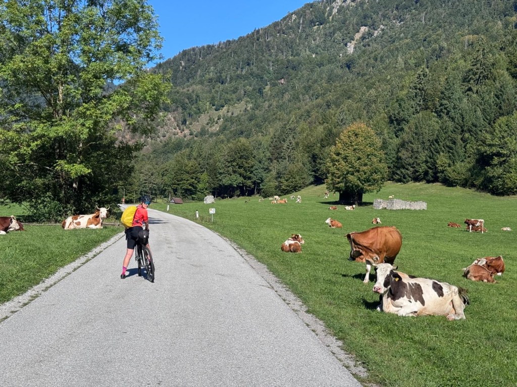
You cycle through Kranjska Gora but the town actually requires a stop!
Soon you arrive just above Tarvisio where we expected the arrival from Slovenia during our outward journey. And so, the first loop of our trip was completed!
Further to Villach was more of a formality if it weren’t for the fact that the Harley Davidsons had planned their European week in Austria. Their roaring was everywhere. Hilarious but annoying! And expensive because all hotels were very busy, of course!
And the diversion we had already encountered while going was now not indicated at all. So we went back on the 83 and crossed the Gail in Unterfederaun.
This time we slept in Hotel Kramer for an almost exorbitant amount… But it is a cute family business with elderly and wide-bodied ladies at the reception matching most guests/motorcyclists or their machines in size….
DAY 13: FROM VILLACH to SPITTAL AN DER DRAU: 41km, 175m ascent, 136 descents. Train to Böckstein and cycle to BAD GASTEIN
To avoid the climb to Mallnizt we decided to take the train in Spittal. There you have several options: to Mallnitz direct or regional trains with a stop in Böckstein… Home – ÖBB)
From Böckstein we cycled the short distance to BAD GASTEIN. (6 km and 105m descent)
Bad Gastein is worth a stopover, especially if you can sleep in the Salzburger Hof! This was on offer for 135 € breakfast included, perhaps as a Sunday and September promotion. The hotel was filled with (American) tour groups; but could still handle a few stray tourists….
The decoration, the restored glamour, the magic of the photos on every floor (with celebrities who make you believe they once stayed in the hotel), the view from the balcony of all those Belle Epoque hotels and villas built on the steep slopes of the city, … make the hotel and the city a recommended experience!
And a walk along all those Sound-of-Music-themes: the waterfall, the dilapidated hotels waiting for huge budgets to be refurbished and the already restored ones…. before or after dinner is highly recommended and good for the glutes!
For dinner we chose Gasthaus Jägerhäusl where the owners each take care of a floor as head waiter. Solid!
DAY 14: from BAD GASTEIN to WERFEN 65km, 370m of climbing and 1079m of descent.
So today we got a good impression of what we “missed” by having taken the taxi on the outward journey…. On second thoughts we would do the climb, now! But bear in mind, it goes down blisteringly hard in Bad Gastein itself, all the way to the cemetery (!)…!
The route remains beautiful until you have passed through Dorfstein. Then a cycle path along the 167 takes you to Klammstein (don’t forget the coffee on the terrace of the Gasthof), again through the tunnel and then to the right, on the official Alpe-Adria route towards Salzburg.
You stay high, rolling (sometimes seriously up) until you reach Schwarzach im Pongau. Then the best part of the route is over. You still follow the Salzach but the banks are mostly taken over by industry.
And despite their names, St Johann and Bischofshofen are not in line for a conviviality prize…
We decided to spend the night in Werfen, with a one-street center, not bad, but with a suspicious number of pizzerias… Slept in Werfenerhof for 110 € with breakfast. Ok.
What a shame: we didn’t visit the castle that was a little further on the route… the “Hohenwerfen Festung” famous from the movie “Where eagles dare”, one of Alistair MacLean’s bestsellers.
DAY 15: WERFEN to SALZBURG: 46km, 288m up, 432 descending. 02:12h
As described on day 1, after Werfen it goes down on a main road, where the locals dare to chase the cobwebs out of their bikes. Only after the left turn just before Golling does it get very cozy, with coffee in Hallein to celebrate.
The castle above Salzburg soon comes into view. And so, you end up where you started: on the Salzach in Salzburg
CONCLUSIONS
- A beautiful but relaxing loop with some unique experiences every day: either the landscape, the pleasure of cycling or both.
- It was our first long cycling holiday in this corner of Europe, and in September. What are the main differences with France? Here most businesses stay open; restaurants and hotels don’t go into an “off season mode”, are more business-like and even more jovial with also bike-friendly check-in hours (usually from 14.00-15.00!) and with no 2-night stay reservation-must… Actually, this part of Europe is more and better geared to the cyclist!
- We would still do our trip like we did, probably combine a few routes…
- And SALZBURG: a few more recommendations in addition to the most popular (Mozart House, Steingasse, ..)
1. Hike the panorama route over the Mönchsberg with arrival at the Augustiner Bräustübl with dinner there. A must do! And good beer: straight from the barrel and not enriched with C02!
2. Untersberg cable car to the Geiereck summit with a view of the Berchtesgaden Alps and hike on the ridge to the Salzburger Hochtron
3. Wasserspiele (Tricky Fountain) in Schloss Hellbrunn: fun!

